Archive for November, 2015

There are hundreds of ghost towns in Colorado, but few can match the beauty of Crystal City, especially in the autumn when the leaves change colors, the air gets crisp, and the clouds cling to the tips of the rugged peaks that surround this tiny hamlet in Gunnison County. Prospectors first came to the valley where Crystal City lies in the 1860’s, finding good ore, but the remote and treacherous climb into the valley discouraged any serious effort to develop the area until the 1880’s. From the 1880’s through around 1915 Crystal City was home to a small community of miners and their families. The population of Crystal City never amounted to much more than 500. The town did have a newspaper, a store, and a the Crystal Club- The hot spot of Crystal City’s social life in the boom years. Today, a handful of people spend their summers here, having restored some of the historic cabins at the site, but nobody lives in Crystal year round. The old Crystal Club with it’s faded sign still stands along the main street through town.

crystalcity13

Fall colors along the upper Crystal River valley

Crystal City is about as remote as a town can get. It lies situated in tiny valley high on the Crystal River at the foot of Schofield Pass. The only road into the town is a narrow, brutally rocky, 4×4 trail from Marble, Colorado which is about seven miles away. There are stretches of this road that are hardly a vehicles width, with sheer drop offs to the river below. The drive into Crytsal City could be described as both “thrilling” and “white-knuckle.” The harrowing seven mile journey to Crystal City is done at a snail’s pace, taking over an hour, the road too narrow and rough to travel at much more than a crawl, but this is one of those magnificent places in Colorado where you want to take it slow- The steep canyon walls leading to Crystal City are overgrown with all different kinds of trees and shrubs, which, in the fall, take on contrasting hues of red, orange, yellow-green, and gold. When looking down into the river below, the crystal clear waters rush over white, blue, green and gray marble stones on the river bottom. A trained eye can watch brook trout playing in the currents. A picturesque lake along the way, and numerous small waterfalls cascading down the cliffs add to the stunning, almost surreal setting of the upper Crystal River valley.

crytsalcity13

Picturesque lake along the trail to Crystal City

crystalcity14

One of the tiny waterfalls along the way

After thrashing and bouncing down the road to Crystal City, the first building you encounter at the town site is one of the most photographed buildings in Colorado- The Crystal City Mill. This unique structure perched on a cliff  above the river, with a wooden shaft running down to the water was an early hydroelectric power plant.  Historic photos show there was a dam next to the power plant, water draining out of the reservoir behind the damn would spin an impeller inside of the wooden shaft, which in turn would spin the turbine of an electric generator housed inside the building atop the cliff. The electricity was then fed to the homes and mining operations of the town.

crystalcity4

Power Plant at Crystal City

Surprisingly, this is where most people stop, take a few photos, turn around, and bounce back down the road to Marble. Many people don’t realize that there is a lot left to see just a couple of hundred yards past the mill. The rest of Crystal City is just as picturesque as the power plant. It’s a nice place to park your 4×4, stretch your legs, and take a walk through the little kingdom paradise, secluded from the rest of the world in it’s idyllic setting. The rows of neat and tidy log homes, some occupied, some vacant, give you the impression that Crystal City must have been a nice place to live in it’s glory days.  The only bad part of Crystal City is when you realize you have to leave! 

crystalcity5

crystalcity1

crytsalcity12

crystalcity11

crystalcity7

crytsalcity10

crystalcity3

crytsalcity6

crystalcity12

crytsalcity9

2016 Historic Gilpin County, Colorado Calendar by Jeff Eberle only $14.99!

gilpcal

2016 Ghosts of Colorado Calendar by Jeff Eberle Only $14.99!

lulu3

Books and eBooks by Jeff Eberle

ldethir


My first blog titled “25 Abandoned Buildings You Must See in Colorado Before They Are Gone” was such a hit and got so much traffic, I figured I better make a “Part II” featuring 25 more buildings you should put on your bucket list…

So, once again, in no particular order, 25 more of the best abandoned buildings in the State of Colorado! Enjoy!

tri5

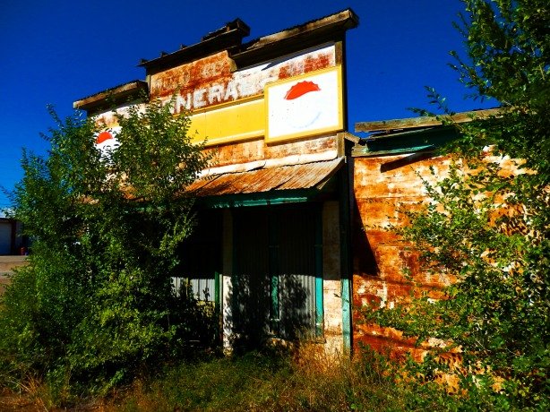
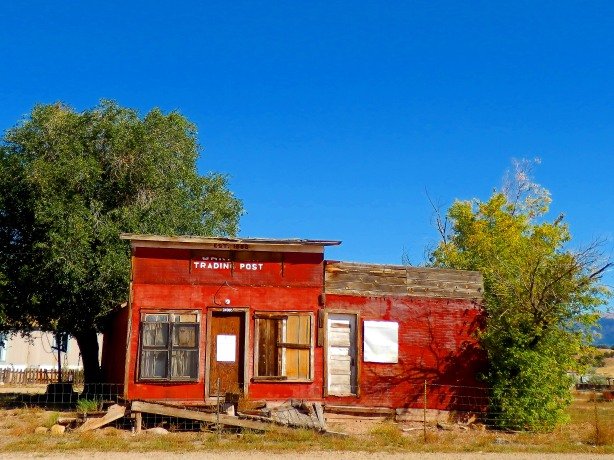
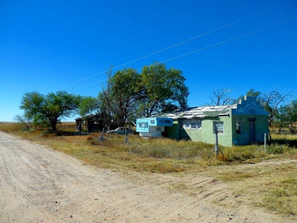
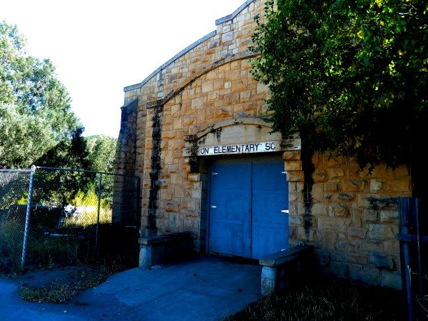
1. General Store- Weston, Colorado

Weston, Colorado still has a number of residents, but you can find this little gem sitting right along Highway 12 as you enter the east side of town. There is a dirt lot alongside the general store where you park, and there are many interesting buildings and houses in the tiny town. Be sure to see the old Weston Elementary School which lies right across the street as well- It has been turned into a private residence in recent years, but the sandstone block construction overgrown with shrubs makes for a great photo. The handful of people I saw in Weston all seemed friendly, smiling and waving, and a couple of kids on bikes looked at me like I was crazy for taking so many photos of that old abandoned store. To get there take Highway 12 (The Highway of Legends Scenic Byway) west out of Trinidad for 23 miles and you’ll drive right through the center of town. There are many other cool old towns and buildings that line Highway 12 along the way, so make a day trip of it.

borden6

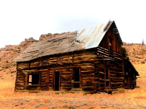
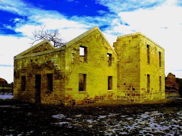
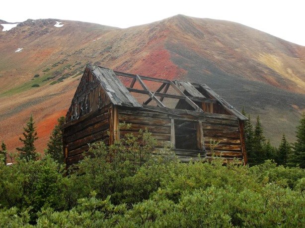
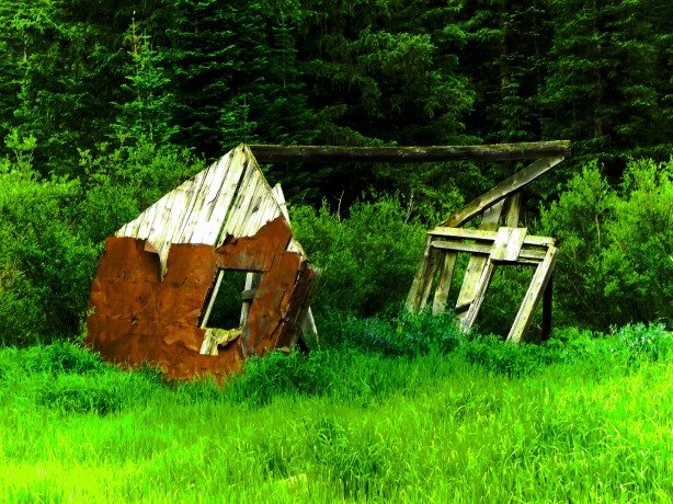
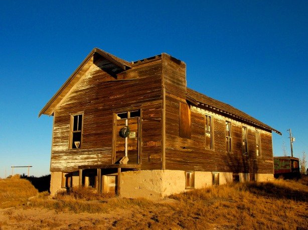
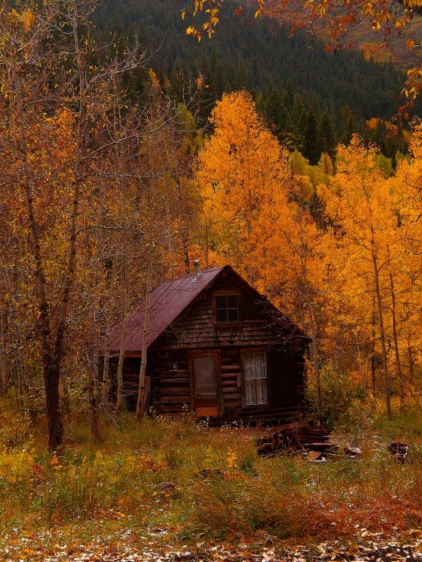
2. Abandoned Homestead(s)- Tarryall Creek, Colorado

In South Park between Jefferson and Lake George, along the banks of Tarryall Creek are a large number of abandoned homesteads, ranches, and cabins, some which are truly remarkable. It was hard for me to pick just one, because each of them deserves to be on the list. Above is just a typical example of what you’ll see along Tarryall Creek. I took my trip in the cold, dead, winter months with a backdrop of clouds and yellowed dead grasses- I’d imagine the Tarryall Valley would be even more striking in the summer months with wildflowers and lush greens. Take Highway 285 south out of Denver towards Fairplay, at the tiny town of Jefferson, turn southeast on Tarryall Road/County Road 77, you’ll enjoy 43 miles of abandoned homesteads, rock formations and wildlife by the time you reach Lake George and Highway 24 on the other end.

agu2

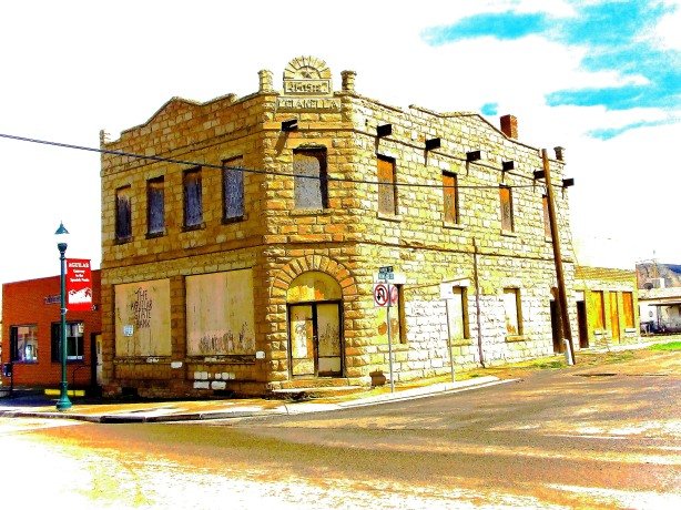
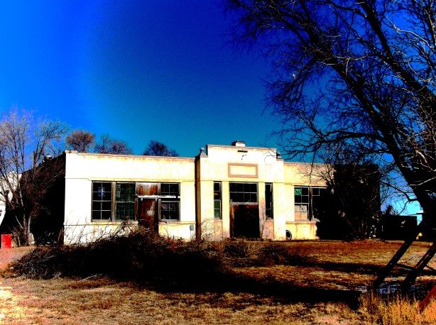
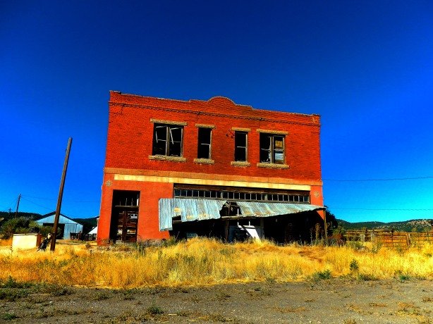
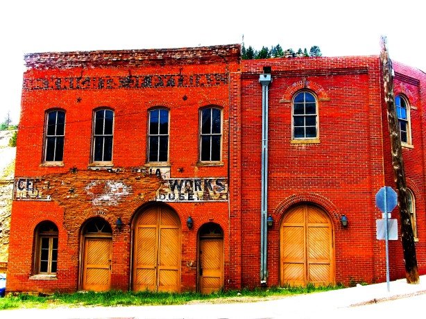
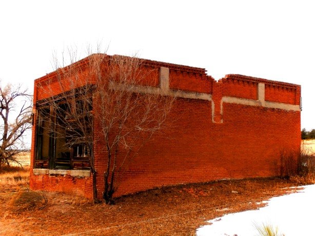
3. First State Bank of Aguilar- Aguilar, Colorado

The Gianella Building in Aguilar, Colorado, more commonly known referred to as the First State Bank building in Aguilar was built in 1910, and closed only a short time later in 1927 when the coal mining empires of the region began to fade.  Also of interest in Aguilar is the sandstone Lopresto building of similar construction and age a block or tow down that street that currently houses Ringo’s Market.  Both buildings, and a number of other vacant store fronts are worth the short side-trip to the base of the Spanish Peaks where Aguilar sits if you are traveling on I-25 in the Trinidad area. Exit signs clearly mark the route to the town just north of Trinidad about 15 miles. Fair warning though- The locals have a lot of town pride, and do not like their town being called a “ghost town” or an “almost ghost town”, so choose your words wisely- I learned the hard way a couple of years ago!

nevadville

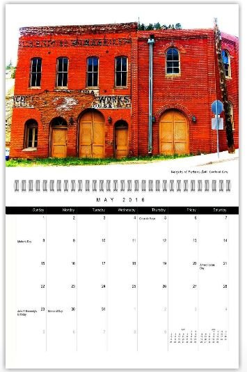
4. City Hall and Fire Department- Nevadaville, Colorado

Thousands of people flock to Central City and Black Hawk every weekend to try their luck in the casinos, or to explore the old buildings and shops of the historic district, but few go the extra mile (literally) to see Nevadaville while they are visiting. Nevadaville was once part of the “Big Three” mining towns that delivered millions in gold ore during the boom years in Gilpin County. Today, Nevadaville is a ghost town, most of it’s buildings having been torn down long ago, their boards and planks used to build homes in Denver in the early 1900’s. Along Main Street in Nevadaville a handful of old buildings remain- The Odd Fellows Lodge, the Saloon, the Bald Mountain Store, and the combination City Hall/Fire Department building. A few old houses and cabins, along with the ruins of the enormous mining operations dot the gulch in all directions around Nevadaville. A few people still have summer homes in the town, and one local told me the year-round population of Nevadaville is now up to two since he moved in! Next time you visit Central City/Black Hawk, pack a camera and take Central City Parkway from Interstate 70 (Exit 243), as you begin the drop into Central City there will be signs and a fork in the road pointing to Nevadaville, follow the paved road up the steep hill about one- half-mile, the road will turn into a good, graded dirt road, and approximately one-half-mile up the dirt road you will find yourself in Nevadaville.

berwind2

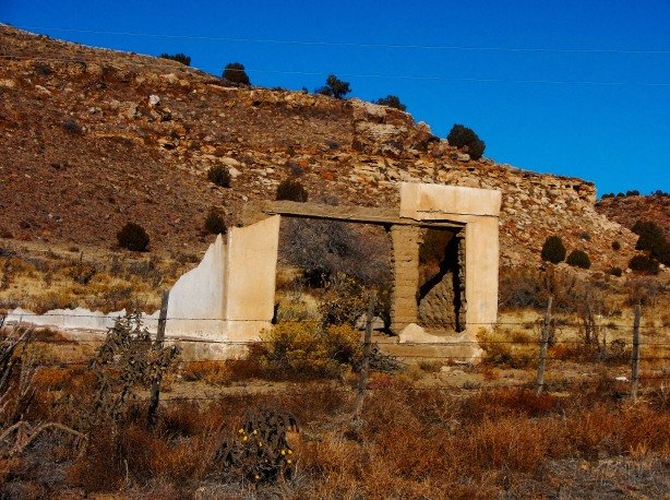
5. Jailhouse- Berwind Canyon, Colorado

The old concrete jailhouse in Berwind Canyon is about the only structure left in the area that is still intact- Nearly all of the other company houses and buildings that lined Berwind Canyon during the coal mining days were leveled by bulldozers in the 1950’s, so the mine owners didn’t have to pay property taxes on the vacant buildings. Foundations, pillars, walls of buildings, coke ovens, even staircases that lead to nowhere cover the sides of Berwind Canyon and give the impression that you are standing among ancient Roman ruins. Today, the canyon is silent in stark contrast to the heyday of the area when over 3,000 people called the canyon home. Berwind Canyon is located southwest of the ghost town and memorial at Ludlow. From Interstate 25 take the Ludlow Exit, drive south past the remains of Ludlow, and keep your eye out for the narrow turnoff on the west side of the road that runs through a one-lane tunnel underneath the railroad tracks. Turn here and go under the tracks this is County Road 40.2 and it will lead you into the “Roman Ruins” of Berwind Canyon.


st5

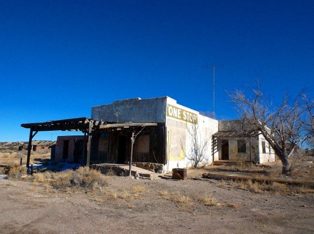
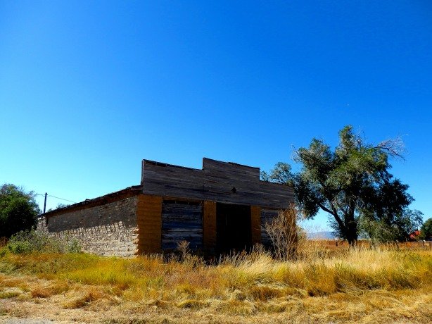
6. Smelter Office or Workshop- Stringtown, Colorado

Stringtown is just south and west of Leadville (hard to determine where Leadville ends and Stringtown begins) along Highway 24. You’ll know you’ve reached Stringtown when you see the massive mounds of black slag, the byproduct of the smelting process where precious metals were separated from the worthless host rock they were found in. Stringtown and it’s smelters were an important industrial suburb of Leadville in the late 1800’s and early 1900’s. Today Stringtown is a cluster of occupied and vacant trailer houses, an abandoned steakhouse/saloon, and a smattering of old buildings dating to the boom era in various states of decay. This old smelter office or workshop sits just off of Highway 24 in the heart of Stringtown. Many other abandoned buildings and forlorn pieces of mining and smelting equipment can be seen all around the town as well.

ramah13

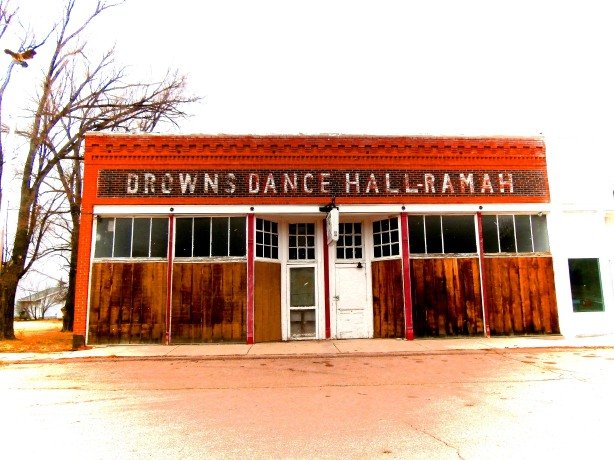
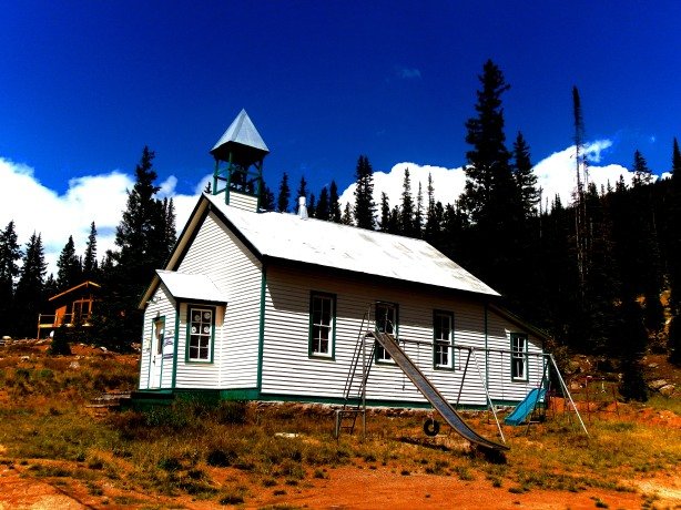
7. Brown’s Dance Hall- Ramah, Colorado

Ramah, Colorado is one of the most interesting places in the state in my opinion. Ramah is the picture perfect “ghost town”, but it is not a ghost town. Many people still call Ramah home, and I see why. It is fantastic little town set deep among gigantic trees, with several blocks of houses, an old business district complete with false-fronted shops, and a public park with a WWI era canon sitting in it.  Old cars sit abandoned throughout the town, most from the 1950’s or earlier, the vast majority of the storefronts are vacant, and I’d say about half of the homes are empty. There is something interesting on every street in town, and the town itself is colorful- the houses and businesses, even the abandoned ones are bright are welcoming. You truly feel as though you’ve traveled back in time to the early-1960’s when exploring the town. At any minute you’d expect to see Sherriff Taylor and Deputy Fife roll around the corner in their black and white squad car. Brown’s Dance Hall pictured above is just an example of the neat character and charm that you will experience in Ramah. To get there Take Interstate 25 south to Colorado Springs, then take the Highway 24 Exit east. Ramah is about 45 miles east of Colorado Springs on Highway 24, several other interesting old towns are along the way as well.

keo2

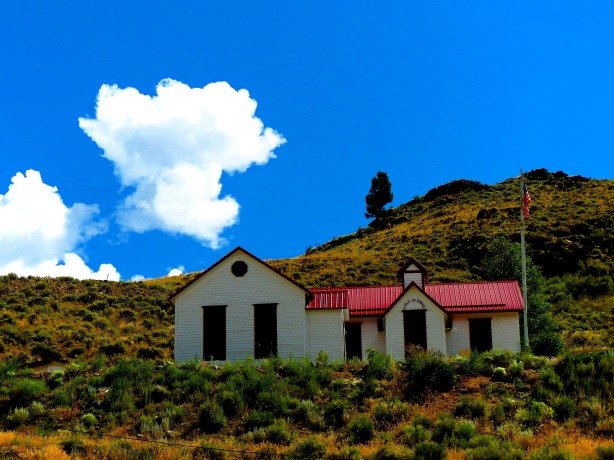
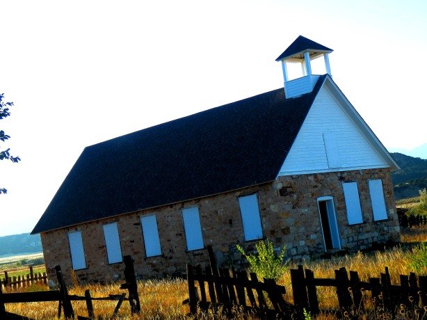
8. Methodist Church- Keota, Colorado

This weathered old church with it’s bell tower missing, having fallen off many years ago sits on the north end of the small, great plains ghost town of Keota in northeastern Colorado. Keota is a true ghost town, with no residents, although many of the properties are still privately owned and marked as such. Chances are when visiting Keota you’ll be the only person there, as was the case when I first visited the town a couple of years ago. The houses and buildings at Keota are in varying degrees of deterioration, one old house, when I visited, was leaning so far to one side it was almost flat to the ground. Keota is a long drive from pretty much anywhere, and there are several routes to get you there from Denver- You can take Interstate 76 to Fort Morgan, then Highway 52 north to New Raymer, then, Highway 14 west out of New Raymer to County Road 390. From 390 you travel northwest until you see the abandoned Keota water tower, and then if you manage to get lost from there it’s your fault. The other route would be taking Interstate 25 north to Highway 14 at Ft. Collins, take the Highway 14/Timnath exit east and travel across the prairie until you reach County Road 390 which takes you north to Keota.

gr6_1

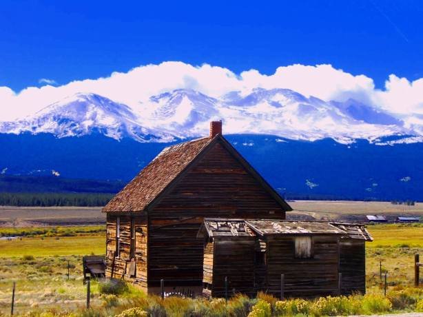
9. Barn and Outhouse- Granite, Colorado

Granite dates to the 1860’s and was an early mining and supply town in the Arkansas River Valley between Leadville and Buena Vista. The town still survives today, with a handful of year round residents and some summer cabins. Granite retains much of it’s old time character, and has plenty of weathered cabins, and old schoolhouse high on the hill, and some false-fronted stores that haven’t rang up a sale in decades. In recent years tourism has brought some life to Granite bringing in fisherman and rafters coming to enjoy the Arkansas River that runs through town. This old barn with it’s stone foundation and outhouse sit on the west side of Highway 24, the rest of the town of Granite sits on the east side of the highway. Getting there is easy, just take Highway 24 south out of LEadville towards Buena Vista, you will pass through Granite about 17 miles south of Leadville.

sac1

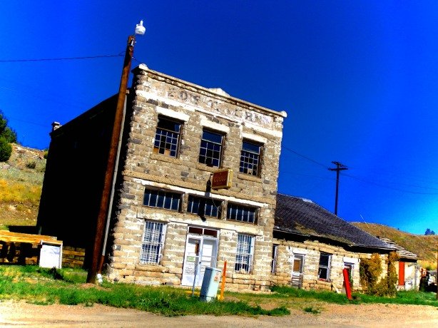
10. General Store (?)- San Acacio, Colorado

I’ve only just begun to explore the San Luis Valley and it’s quickly becoming one of my favorite parts of the state. (I can have more than one right?)  The stunning contrast of the flat grasslands of the valley itself, and the snow capped spires of the Sangre de Cristo Mountains that surround it are truly breathtaking. Numerous small towns line the valley floor, and I’ve never met friendlier people than those in the San Luis Valley- Every passing vehicle on the road greets you with a smile and a wave- Not the horn and obscenities like those of us in or close to the metro area are accustomed to. The locals I’ve met in gas stations and stores in the San Luis are just down to earth, friendly people, proud of their valley and it’s heritage, and always willing to share a story or lend a helping hand. San Acacio is one of the tiny towns in the San Luis Valley, and this wonderful old store (or what I’m assuming was a store) sits just off the side of County Road 142. From Denver take Interstate 25 south to Walsenburg, Highway 160 west from Walsenburg, up over La Veta Pass, to Ft. Garland, from Ft. Garland take Highway 159 south to San Luis (the oldest town in Colorado dating to 1852) and from San Luis head west on County Road 142 to San Acacio.  From Denver is around 250 miles.

lastchance2

11. Hotel- Last Chance, Colorado

There’s not much left to see at Last Chance, Colorado- Most of what was left being lost to a prairie fire a few years back. Luckily, this awesome old Hotel building survived. There are a couple of other buildings at the site as well including an abandoned Dairy King and a home. Last Chance is located on the desolate eastern plains in Washington County. There’s not much to see in the town, and even less on the road out there. Take I-70 east, then Highway 36 east, keep driving east, and when you think there’s no more east left in Colorado it’s another hour east of there on Highway 36…it’s actually only 80 miles from Denver, but it seems like a lot more!

big5

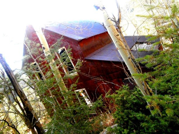
12. The Big Five Mine Office- Camp Frances, Colorado

I stumbled onto the Big Five Mine Office by accident a few years ago. I was searching for, and thought I had found the post office building at the Puzzler town site in Boulder County. I was wrong, consider I had read my map wrong and wasn’t at Puzzler. So this old red building with white trimmed windows buried in an aspen grove I had stumbled upon was a mystery to me for a few weeks. Once I flipped my maps around and determined the origin of my error, I learned that this building was the last structure at the Camp Frances site. Camp Frances was a busy mining camp in the Ward District in the 1890’s.  The old mine office is a really interesting building if you can find it- And, to add to the mystery of Camp Frances, I’m not sure if it is on public or private property. I reached the building by taking Highway 119 (Peak-to-Peak Highway) north out of Nederland. Just south of Ward take Gold Hill Road east, then at the first major fork in the road, turn left (north) on to Sawmill Road. Sawmill Road drops off fairly steeply and when you screech to halt in a cloud of dust at the bottom, turn left, then immediately turn left again onto the road that sits right next to Sawmill Road (confused yet?) Travel west up this gulch back towards Highway 119. You’ll start to see evidence of a massive EPA reclamation project, then you’ll come to a newer home on the left hand side of the road. A large pack of snarling and barking dogs will charge out from under the porch of the house and circle your vehicle for 7 to 10 minutes as you try to figure out how to continue up the hill without running any of them over. Once the dogs get tired of barking at you and you are safely out of their territory, the road will get a bit steeper and as you pull the incline you’ll see the mine office and a tall rock wall (the remains of the blasting powder bunker) on the slope to your left. You can pull right up to the mine office and explore it…But, like I mentioned, it is very unclear whether or not the site is on public, private or EPA controlled land.  If anyone knows the answer, please contact me.

ironton5

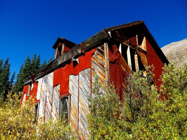
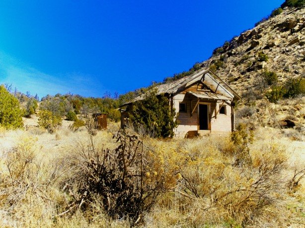
13. Any of the Abandoned Houses- Ironton, Colorado

There is nothing disappointing about Ironton, between Ouray and Silverton in the San Juan Mountains. If you haven’t been there it is a bit difficult to find at first. but it is well worth the effort. There are a number abandoned homes and stores at the site, which sits buried among pine and aspen trees along the road to Red Mountain Pass. Many of the structures are stable enough to enter with a light step. In September of 2013 I determined my best bet for avoiding the floods ravaging the front range would be to go hide out in the San Juans for a few days, it was on this trip that I first found Ironton. I was on my way to Silverton and pulled off the side of the road and hiked a half-mile or so up an old dirt road to the town. While snapping photos inside one of the old houses, a Texan tourist appeared out of nowhere and said “Hello!”, causing me to drop me camera, jump eight feet in the air and scream, giving me a mild heart attack. Ironton can be found by taking “The Million Dollar Highway” (Highway 550) south out of Montrose and through Ouray. As you climb Red Mountain Pass, there will be a large rusty red tailings pile from the mining activity on your left hand side, here there is a parking lot and some trailheads. A rough 4×4 road skirts the edge of Highway 550 south for 3/4 mile or so, and at the end of this 4×4 trail buried deep in the trees is Ironton. You can’t see Ironton from Highway 550 even though it is right off the side of the main road. A lot of people miss it, but if you can find it there are around 10 buildings left at the site.

10014264_10203892444331710_2472953589546986721_o

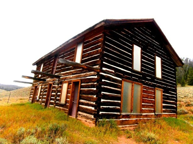
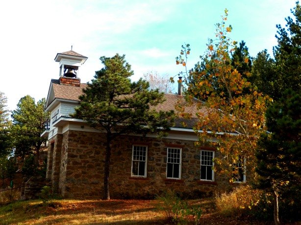
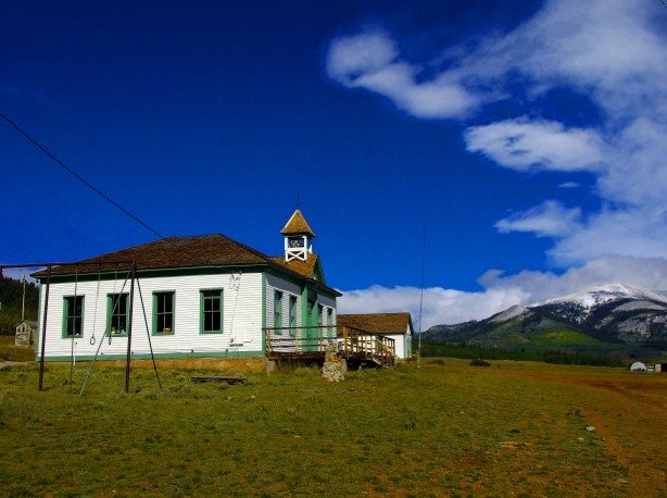
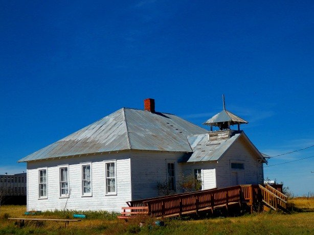
14. Lake Gulch Schoolhouse- Lake Gulch, Colorado

Lake Gulch, like Nevadaville, is just a mile so beyond Central City, and very few people have ever heard of it. This old red brick schoolhouse, now faded to pink, is the only period structure still somewhat standing at the site. There are some newer concrete mine buildings close by though. A few mining ruins, some old wooden fence, a few rock foundations and a stone wall or two are all that remains other than the school. Lake Gulch was a mining camp to the south of Central City, east of Russell Gulch.  Getting there today is via Spring Street in Central City to Virginia Canyon Road, at the the top of the hill there is a fork, the right fork of Virgina Canyon Road is marked and leads to Idaho Springs, the left fork is Lake Gulch Road which runs past the KOA campground and some apartments. At the turnoff to the apartments, the pavement ends. Continue on down into Lake Gulch on the dirt road, the ruins of the schoolhouse are about a mile down on the right hand side, on private property. If you’re lucky like I was you’ll catch a rainbow leading to the ruins.

lc15

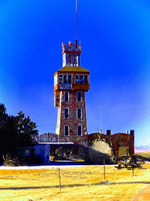
15. The Genoa Wonder Tower- Genoa, Colorado

I do not know if the the Genoa Wonder Tower is “abandoned” but it has been permanently closed to the public in recent years by it’s current owner, and now, sadly,  sits in a forlorn state. This unusual tower is located on the west end of the town of Genoa, about 100 miles east of Denver on Interstate 70. The tower was a tourist trap built in the 1920’s called the “World Wonder Tower” or “The Genoa Wonder Tower.” It is claimed that if you climb to the observation deck of the tower you can see six states, whether that is true or not is speculation, but it was widely touted in advertising for the tower. Inside the lower level of the tower was a museum of oddities and a gift shop. The upper walls of the museum were lined with case upon case of arrowheads and other Native American artifacts found by area farmers. Several old cars and vintage trailers sit sunk in the mud around the tower and add to it’s appeal.  Getting there is by taking Interstate 70 east 102 miles from Denver.

buckskin

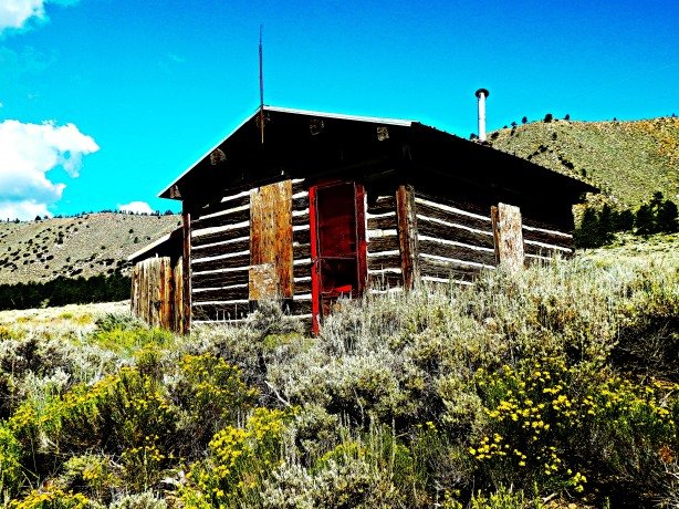
16. Bunk House- Buckskin Gulch, Colorado

I don’t know any of the history behind this old bunk house in Buckskin Gulch a few miles northwest of Alma. I’m even speculating that it was a bunk house, but it fits the mold of several other I’ve seen. There was a great deal of mining done in Buckskin Gulch dating all the way back to the 1700’s when a few Spanish explorers stopped and mined some gold silver in the area with the “help” of Ute Indian slaves who later rebelled and disposed of their Spanish masters. The area has been extensively worked ever since, and this building probably dates to the late 1890’s based on it’s construction. Judging by the debris inside, it’s a popular place to drink canned beer. You can find the bunk house by taking Highway 9 either south out of Breckenridge to Alma, or north out of Fairplay to Alma. Once you’re in Alma look for the tiny sign marked “Buckskin Gulch/Kite Lake” that points west through the houses just north of Al-Mart (or ask any of the locals) follow the dirt road up Buckskin Gulch about 5 miles and the bunk house will be on your right hand side. Be sure to stop in Al-Mart while you’re there- It’s a great little convenience store that has everything you could ever need, and the staff is friendly too.

tur3

17. Any of the Miner’s Cabins- Turret, Colorado

Turret was a mining town 12 miles from Salida in the Arkansas River Valley in the late 1800’s. It sat abandoned, forgotten and unmolested for much of the 20th Century. Then, in recent years, people once again “discovered” Turret and it’s beautiful setting, and now the old and forgotten is being rapidly replaced by the new. Modern summer cabins are being built at Turret, and the reminders of “old” Turret are vanishing quickly. A number of the original cabins still remain at the site, including one that has been restored which was the original Post Office, but the majority are falling apart and it won’t be long until they vanish. Turret recently made news headlines when a crazy man who lived there blew himself up making homemade bombs…But that episode shouldn’t deter anyone from visiting the site. Getting to Turret can be a chore, but having an old-fashioned paper and ink Colorado atlas will prove beneficial. From Salida you can get there by taking 3rd Street to County Road 175. Take County Road 175 to County Road to County Road 184 which will take you to Turret. Sounds easy enough, but the road zigs and zags and disappears in the sand, and there are random, unmarked forks, blind hills and corners, and suicidal deer and rabbits hellbent on running you off the road the entire length.

ws1

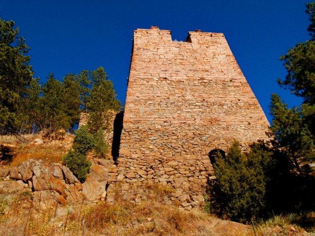
18. Chlorination Mill- Wall Street, Colorado

When most people hear “Wall Street” they think of stockbrokers, buzzers and bells, not a quaint and sleepy Colorado ghost town bypassed by the modern era. Wall Street was named in the late 1800’s for the east coast capitalists who funded and owned the mines in the area. At the time, an elaborate new system of extracting gold from host rock using chlorine was developed. The investors and miners of Wall Street built what was to be the first chlorination mill in the state. How exactly it worked, I have no idea, but the remains of the mill at Wall Street are very impressive to this day. A towering stone foundation that was apparently used to store ore for the mill rises above the tiny town of Wall Street in Boulder County. As massive and imposing as the foundation is, it is also very well camouflaged and blends into the mountainside- It took me two visits to Wall Street before I noticed it even existed, now, it is the first thing that strikes my eye when I visit the town. There are several other old buildings at Wall Street including the Assayer’s Office, which, in summer months is open to the public and serves as a mining museum. To get there take Canyon Avenue west out of downtown Boulder, then up into Boulder Canyon, turn right on to  Four Mile Canyon Road and take this to Salina. At the south edge of Salina, there will be a dirt road heading west, this is the road to Wall Street, follow this dirt road up a couple of miles and first you’ll see the Assayer’s Office, and directly behind it is the foundation of the chlorination mill.

nunnx1

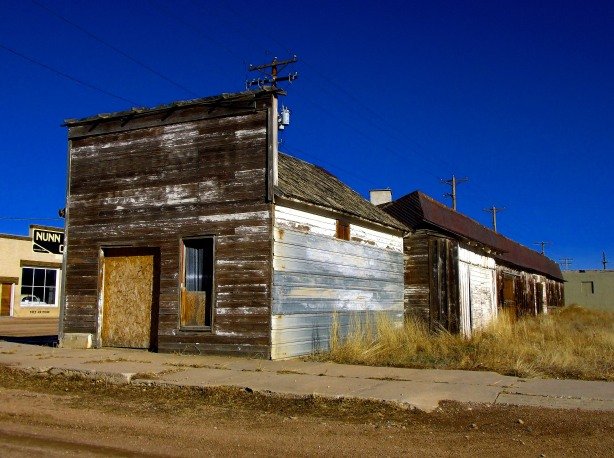
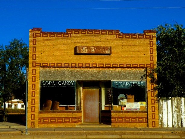
19. Store Front, Nunn, Colorado

There’s just something about old false-fronted stores that I love. They’re simple, common, and really not very awe-inspiring in their standard form, but the style speaks of the past, and a simpler time when businesses were small, “Mom and Pop” operations, not mega-conglomerate super retailers like we know today. This tiny building in Nunn is the simple store front of yesterday. What makes this store front even more appealing (at least to me) is the neat row of power lines in the background that line up perfectly with the roof tops of you get just the right angle with your camera.  Nunn is pretty quiet these days, but still has a few folks hanging around. Judging by the street corners, lots and backyards, every single Studebaker in the United States apparently went to Nunn, Colorado to die! So if you’re looking for parts for your ’57 Golden Hawk I’d suggest checking Nunn. The water tower in town reads “Watch Nunn Grow.”  Nunn is north and east of Ft. Collins on Highway 85 just before you hit Wyoming.

farasitabk2

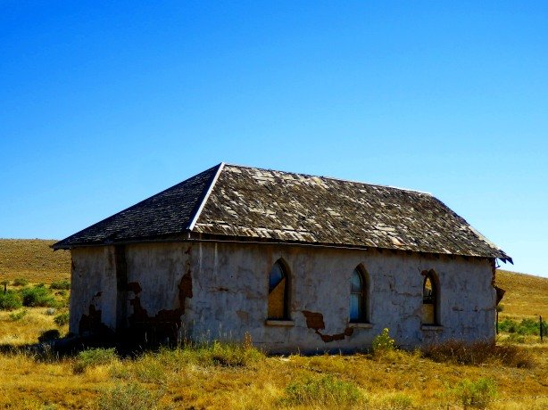
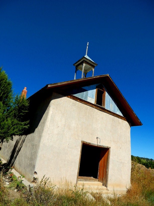
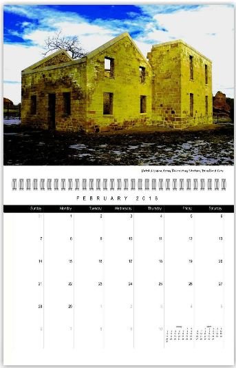
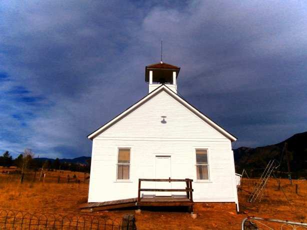
20. Church- Farisita, Colorado

I don’t know any of the history behind this abandoned stucco church at Farisita. I’ve read that it was a Methodist Church, but that seems strange to me since Farasita was a Spanish/Mexican settlement, and there is a Catholic cemetery directly across the street. Farisita was first known as “Fuerte Talpa” or “Talpa” and the Spanish built an adobe fort there around 1820, to protect the northernmost frontier of the Spanish Empire in the New World from incursions by the expanding United States. The soldiers at the distant outpost of Talpa were incessantly harassed by Ute Indians, and, one particularly vicious attack, coupled with the Mexican revolution of 1821, led to Fuerte Talpa being abandoned. After 1821 and Mexican independence from Spain, Mexican settlers returned to the area and Farisita sprang up at roughly the same location of Talpa on the Huerfano River.  Today Farisita is nothing more than this abandoned church, an empty store front, one occupied house, and the cemetery. Getting there is via Highway 69 west out of Walsenburg.

Hwy 350

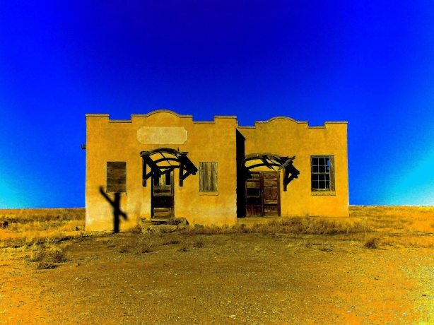
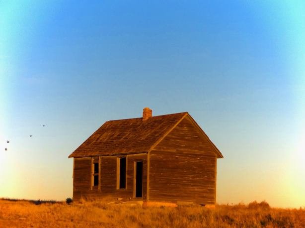
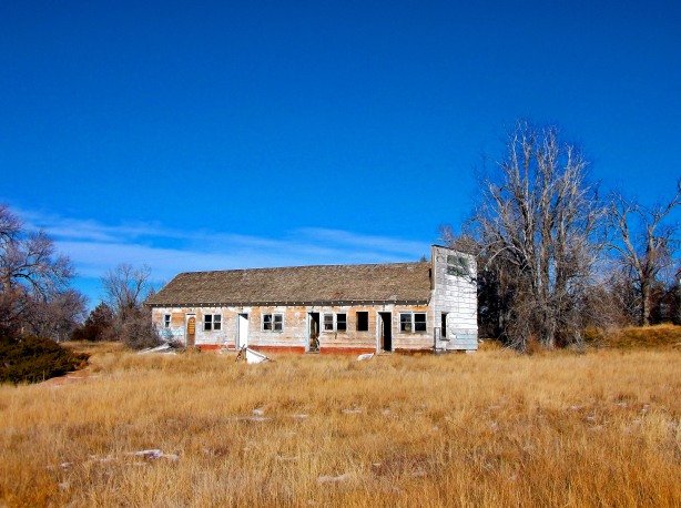
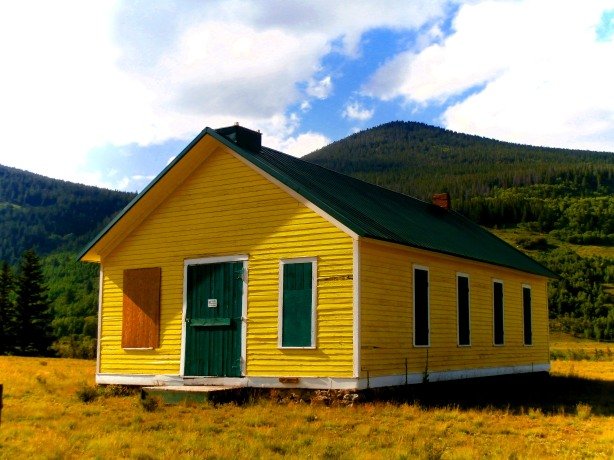
21. School House- Tyrone, Colorado

The architecture of this old school house at Tyrone makes it stand apart from the rest, and it’s location, standing alone on the wind swept, sandy prairie east of Trinidad make it one of the most picturesque buildings in the state.  Tyrone is another of the tiny dust bowl towns that line Highway 350 between Trinidad and La Junta. There’s not much left of Tyrone other than this school, the ruins of the general store and a couple of abandoned farm houses nearby.

cmo3

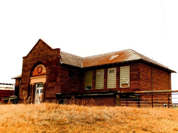
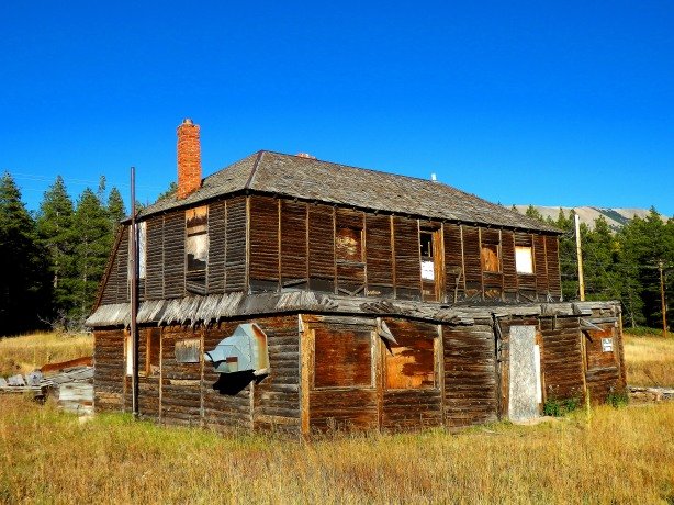
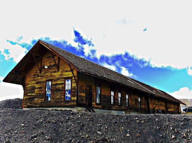
22. The Odd Fellow’s Hall- Como, Colorado

This unique structure as known as the “Odd Fellow’s Hall” in Como, Colorado. It is a very unusual building in the sense that it has an octagonal, second story cupola with windows on all sides which is something you don’t see very often…actually, I don’t remember ever seeing another building like this. The building is privately owned and was recently for sale.  Como is easy to reach by taking Highway 285 south out of Denver towards Fairplay. Como will be along way at the east foot of Boreas Pass just past the town of Jefferson. Como has an eclectic mix of empty and occupied homes and store fronts, and a fantastic old railroad depot with a sprawling two-story white and green hotel next to it. Just a warning though- Como is always cold and windy no matter what time of year you visit.

sanluis

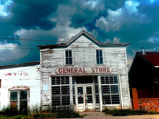
23. General Store- San Luis, Colorado

San Luis is Colorado’s oldest continuously occupied town being founded in 1852. It is a beautiful town in a scenic location surrounded mountains, ranch land and creeks. There are a number of interesting buildings in San Luis, most are still occupied, but this old general store sits vacant about one block off of the main street through town. Be sure to look up on the bluffs overlooking town to catch a glimpse of the mission style Catholic church built in 1886- It is one of the finest examples of Spanish Colonial style architecture in the state. To get to San Luis take Interstate 25 south to Walsenburg, head west out of Walsenburg on Highway 160, go over La Veta Pass to Fort Garland, head south out of Fort Garland on Highway 159 to San Luis.

hull8

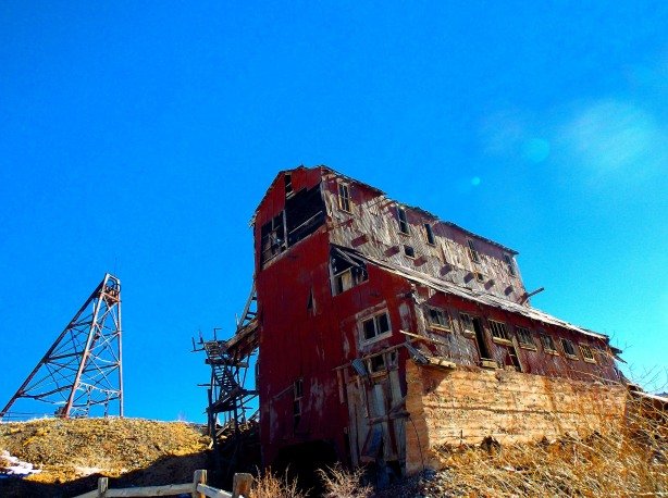
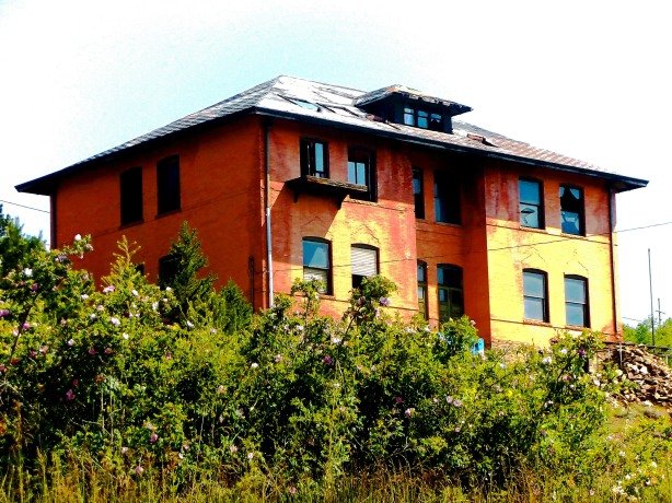
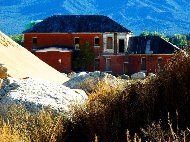
24. The Vindicator Mill- Goldfield, Colorado

The Vindicator is a towering mill building near Goldfield and Victor, Colorado. During the peak years of the gold boom in the Cripple Creek region, the Vindicator was just one of many of the giant mining companies that smothered the hillsides. Today the Vindicator sits in ruins, looming over mine workings, dilapidated buildings and rusty mining equipment throughout the valley below. A foot path has been made in recent years that runs down through the maze of mine workings at the Vindicator site and if you are into rusty industrial equipment this is place is right up your alley. Getting to the Vindicator is by taking Highway 24 west out of Colorado Springs and following the signs to Cripple Creek off of  Highway 67. From Cripple Creek take Highway 67 south to Victor (about 5 miles) spend some time enjoying the vintage painted advertising all over the old buildings in Victor, then take County Road 81 north about one mile and the tiny town of Goldfield will be on your right, across from Goldfield you will see numerous old mine buildings, a couple of trail heads and towards the top of the hill the Vindicator looking down over everything.

rc2

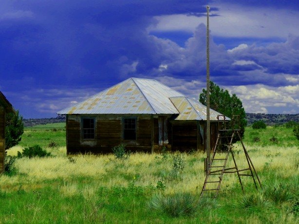
25. The Rock Creek Stagecoach Depot-  Routt County, Colorado

I came across the Rock Creek Stage Depot while on a fishing trip a few years ago. I’d noticed once before many years ago as a kid while on a fishing trip with my dad, but it just looked like an abandoned homestead off in the distance and I never thought much more of it until I returned to the area recently. I stopped to check it out this time, and was surprised to see it was actually an old stagecoach depot dating to the 1880’s on the route between Kremmling and Yampa. In recent years the Routt County Historical Society has done some preservation work to the building, and mounted a plaque with the depot’s history at the site.  To find the Rock Creek Stage Depot take Highway 9 north out of Silverthorne to Kremmling, from Kremmling take Highway 40 north  past Wolford Mountain Reservoir to the intersection with Highway 134. Travel west on Highway 134 roughly 18 miles, where there will be a turnout and a dirt road heading south marked “Rock Creek”, follow this dirt road south a mile or two and the stage depot will come into view.

IF YOU ENJOYED THESE CHECK OUT THE LINKS BELOW! THANKS!

25 Abandoned Buildings In Colorado You Must See Before They Are Gone

25 Forgotten Cemeteries and Burial Plots of Colorado

The Reynolds Gang Unmasked- The Legend, The Truth, The Treasure

The Reynolds Gang Unmasked- The Legend, The Truth, The Treasure


In our modern world where almost every school is a sprawling, nondescript rectangle of brick and mortar housing hundreds of students, it is interesting to take a step back in time and revisit what our schools used to look like.   I’ve taken a lot of photos over the years of historic schools in Colorado, and here is a collection of some of my personal favorites. Enjoy!

gtownschool

1. Georgetown, Colorado

malta1

2. Malta, Colorado

sunshine7

3. Sunshine, Colorado

malachite1

4. Malachite, Colorado

tar11

5. Tarryall, Colorado

Hwy 350

6. Tyrone, Colorado

splume4

7. Silver Plume, Colorado

c6

8. Como, Colorado

penrose3

9. North of Penrose, Colorado

elkh11

10. Elkhorn, Colorado

lg31

11. Lake Gulch, Colorado

bran3

12. Branson, Colorado

clearcreekschool

13. Clear Creek Canyon, Chaffee County, Colorado

ludlow5

14. Ludlow, Colorado

OLYMPUS DIGITAL CAMERA

15. Tolland, Colorado

westonschool1
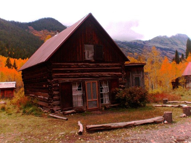
16. Weston, Colorado

math1

17. Matheson, Colorado

Schoolhouse HWY 24-2

18. Along Highway 24 South of Leadville, Colorado

Buckingham School

19. Buckingham, Colorado

thatcher1

20. Thatcher, Colorado

mont2

21. Montezuma, Colorado

lc31

22. Cope, Colorado

graniteschool

23. Granite, Colorado

st12

24. Russell Gulch, Colorado

 downie125. Downieville, Colorado

2016 Colorado Ghost Town Calendar by Jeff Eberle Only $14.99!

lulu1

In no particular order here are 25 of the best abandoned buildings in the State of Colorado. Some are relatively well preserved, others are in an advanced state of decay or collapse. Enjoy!

mod8

1. Grocery Store- Model, Colorado

Few people have heard of Model, Colorado, but in my opinion it is one of the best ghost towns in Colorado. Model is a 1930’s era town located along Highway 350 in Las Animas County between Trinidad and La Junta. The town has several empty storefronts, including this fantastic grocery store with vintage advertising, as well as  a couple of blocks of abandoned houses- But beware, Model is guarded by a vicious dog that will attack you and your vehicle if you cross into “his territory” so stay in the car with your windows up!

gardner1

2. Trading Post- Gardner, Colorado

Gardner is a small town about 25 miles west of Walsenburg along Highway 69. There are numerous abandoned homes and buildings, along with many that are still occupied in Gardner. It’s a quiet, pretty little town with the Sangre de Cristos towering over it to the west. As you enter town from the east you’ll find the old Gardner Trading Post pictured above which was built in 1867.

Apex

3. Hotel- Apex, Colorado

This old building is claimed to have been a hotel during the boom time of Apex and the Pine Creek Mining District in the late 1890’s. It looks a bit small to me to have served as a hotel, but regardless of what it was or wasn’t, it is a great old building with it’s leaning false front, and swaying logs. It is registered as a Gilpin County historic site, and efforts have been made in recent years to stabilize the old building, however the heavy winter snows that hit Apex each year have taken their toll. Apex is roughly 7 miles nortwest of Black Hawk, it can be reached by taking Apex Valley Road off of Highway 119 a mile or so past Black Hawk, follow the road along Pine Creek up the narrow valley about 6 miles to the ghost town of Apex. The road can be rough in spots and a 4×4 is advised if visiting in the snowy months.

yam1

4. Crossans Market- Yampa, Colorado

Yampa is a beautiful town situated along the west edge of the Flattops Wilderness in the Yampa River Valley. Yampa is a sportsman’s paradise offering excellent hunting and fishing opportunities in every direction. Yampa also has numerous interesting buildings dating to the late 1800’s and early 1900’s, most are occupied, but the Crossans Market pictured above is currently vacant. An effort is underway to restore and preserve the old market for future generations. Yampa is located in between Wolcott and Steamboat Springs on Highway 131.

Bradford House

5. The Bradford City House- Ken Caryl, Colorado

Bradford City was an early settlement along the foothills west of Denver. The town was planned to be a major supply center and stagecoach stop on the way to the gold fields of the Rockies. Construction of the Bradford City House began in 1861, and makes it one of the oldest permanent structures in Colorado. The house served as a store, stage stop, and hotel in it’s early years, was added on to a couple of times, and later became the main home of a private ranch. It has sat abandoned since the 1920’s. Perhaps the most interesting fact about the Bradford City House was during the Civil War, Major John Chivington used the house as a Union Army recruiting center. Today the Bradford City House lies within the private Ken Caryl Ranch residential neighborhood. Attempts were made to have it torn down because the residents thought it was an eyesore, but preservationists intervened and saved the building. The building has been stabilized and now sits in a park, behind a protective fence. Access to the building is limited due to it’s location inside a private neighborhood.

wap1

6. Mine Office and Store- Wapiti, Colorado

The Wapiti Mine Office and Store is a remarkable structure that is just about to disappear if efforts aren’t made to protect it. Wapiti (also known as Victoria for a short time) was one of the numerous mining towns that dotted the mountain sides high above Breckenridge in the 1800’s. Nothing is left of the town today except for a some tailings piles, the Mine Office/Store, and an outhouse. A 4×4 trail that runs past the site has become increasingly popular over recent years, and unfortunately, vandals have begun to destroy the Mine Office/Store, ripping the log walls of the rear section down to use as benches around a fire ring where evidence shows the dressed boards from the front and sides of the building have been burned.  Although destruction or vandalism of historic buildings over 50 years old is felony, the law is hard to enforce in areas as remote as Wapiti. Sadly, if actions aren’t taken to stop the destruction, the Wapiti Mine Office/Store will be totally gone. Due to the fragile state of the building I prefer to not give directions to it. UPDATE: Unfortuantely, as I feared, vandals toppled this old building recently, and now what remains lays flat on the ground. Many of the boards and logs used in its construction have been burned in a nearby firepit. The outhouse, which was a short distnce away down a wooden boardwalk has also been toppled and sits in pieces. ENJOY OUR HISTORY, DO NOT DESTROY IT PLEASE!

rugst1

7. General Store- Rugby, Colorado

Thousands of people buzz by the abandoned general store at Rugby, Colorado every day and never notice it- This impressive red brick building lies just west of I-25, literally 100 yards off the side of the road about 15 miles north of Trinidad. There is an overpass at the site that steals your attention as you drive under it, and people seldom notice the building sitting at the old town site.  Taking Exit 41/Rugby Road as you travel south on Interstate 25 will take you down a pot-holed and rough stretch of pavement that runs behind the store and skirts the foothills to the west. You can see the store on your left  as you drive down this road, however it does sit on private property, and an occupied ranch house is right next to the building.

querida3

8. The Last House- Querida, Colorado

Querida was a mining town in the late 1800’s/early 1900’s located east of Westcliff/Silvercliff. The town sprang up to house the workers of the Bassick Mine. Today all of the town except for this lone house is gone. The monstrous tailings pile from the Bassick Mine can be seen across the road from the old house. Getting to Querida is easy from Westcliff/Silvercliff, just take Highway 96 east about 10 miles, and look for County Road 341. Go south on 341 and the abandoned house that marks the site will be on the right hand side of the road.

carz21

9. The Soda Shop- Pritchett, Colorado

It appears that the entire business district of Pritchett, Colorado is abandoned or vacant these days, and the Soda Shop is the crown jewel of them all. You can look in the windows and still see the chairs and the counter, and the faded and peeling paint on the windows advertise “Soda, Candy, Cigarettes.” Pritchett can be found in Baca County, in the far southeast corner of Colorado. Getting there is via Highway 160 east out of Trinidad.

Ashcroft

10. Hotel- Ashcroft, Colorado

The hotel at the ghost town of Ashcroft, Colorado is the quintessential image that comes to most peoples minds when they think of a “Ghost Town”- It has that haunting, forlorn, old west feeling to it, and when you see it you’d expect a pack of dusty cowboys to be sitting around a table inside playing cards and smoking cigars. The hotel at Ashcroft is a definite “bucket list” destination for the ghost towner, and the rest of the town is just as appealing. Ashcroft is on the National Register of Historic Places, and is cared for by the Aspen Historical Society. Ashcroft is located about 12 miles south of Aspen by taking Castle Creek Road at the roundabout on Highway 82 on the west edge of Aspen. A small fee or donation is expected to visit the site, and there is a small lock box to deposit the money in near the trailhead that runs through the ghost town.

gen62


11. Miner’s Cabin- Geneva City, Colorado

This fantastic old cabin has weathered the elements at nearly 12,000 ft. elevation for over 100 years! Geneva City is a remote ghost town on the far southern edge of Clear Creek County, situated at the very top of Geneva Gulch along the headwaters of Geneva Creek. Surrounded by towering, snow capped mountains stained red from their high iron content, Geneva City is among the most picturesque ghost towns in Colorado…if you can find it! Getting there is not easy, and requires a long, steep drive up a rocky, extremely narrow 4×4 trail. The trail to Geneva City starts as the turn off to the Geneva Gulch Campground off of Guanella Pass, drive on past all of the campgrounds, continue on past the Shelf Lake trailhead, then up a treacherous, rocky patch through private property. You just keep following this trail up the hill, eventually you reach the ruins of two old cabins and a small lake. There is a fork in the road that branches left and goes over a hill, take this fork and you will drop down into the basin where Geneva City lies.

pythias

12. Knights of Pythias Lodge, Central City, Colorado

This great old fraternal order lodge building in downtown Central City had it’s roof cave in under heavy snows last year, and the out-of-state owner nearly tore it down as a result. The State Historical Society intervened and work was done over the summer of 2015 to stabilize the crumbling brick walls of the building. The future of the building remains unclear at this point. The building is located adjacent to the Century Casino, and next door to the Post Office in Central City. UPDATE: This building was listed for sale in 2019. Shortly before the Covid-19 hysteria of 2020 closed the nation down, a fence was put up around the structure and a demolition trailer was parked inside the perimeter. Whether the trailer was for interior rubbish disposal, or demoltion of the entire building is unknown. I truly hope someone purchased the structure and plans to renovate it and not demolish it.

ms8

13. Ed’s Tavern- Starkville, Colorado

Ed’s Tavern is a two-story sandstone block building with a lot of character located in Starkville. The lower level of the tavern may still be occupied or used as storage. The semi-desert setting of this old coal mining town makes for a striking backdrop to the sandstone and adobe structures that line it’s streets. Starkville is still a populated place, and is somewhat of a suburb of Trinidad, Colorado. It can be reached by taking Interstate 25 south from Denver to Trinidad, then take Exit 11/Starkville.

sanjose1

14. Saloon or General Store- San Joseville, Colorado

San Joseville is a mystery among Colorado towns. Nobody is quite sure when it was first settled by Mexican ranchers, and nobody is quite sure when it vanished. The newest markers in the nearby Martinez Cemetery date to the mid-1890’s, so it is safe to assume that San Joseville faded at about that time. Today, all that remains of this little ranching community is the ruins of what was either the saloon or general store.  San Joseville is located  about 35 miles southeast of La Junta, Colorado along the Purgatoire River, along County Road 804. The canyon it is found in is called “Nine Mile Bottom” by the local ranchers. The town site is on private property but can be seen easily from the road.

perigo4

15. Miner’s Shack- Perigo, Colorado

This precariously tipping miner’s shack in Perigo, Colorado amazes me each spring when the snow melts and the road in to the site becomes passable- I’m sure that every winter will be this shacks’ last, but defying all odds, each spring the old shack is still standing. Perigo was another of Gilpin Counties many mining towns of the 1800’s, and once had a store, a saloon, and an enormous 6o-stamp mill that pulverized ore from the area mines. Perigo struggled into the 1930’s as a supply station, but rapidly disappeared after that. Today the site of Perigo is marked by a number of  tin-sided shacks similar to this one, one dressed lumber house, and the ramshackle ruins of the huge stamp mill. Getting to Perigo is via Gamble Gulch Road one mile south of Rollinsville off of Highway 119. Follow Gamble Gulch Road up the narrow, overgrown valley, and eventually you will come to a tiny meadow where the ruins of the town can be seen among the tall grass and pine trees.

medina1

16. Abandoned Catholic Church- Medina Plaza, Colorado

This abandoned church at Medina Plaza, Colorado sits off the shoulder of Highway 12 west of Trinidad. There is a small turnout where you can park, and the church appears to be on public land.

Caribou

17. Assayer’s Office- Caribou, Colorado

A couple of stone buildings- one supposedly a hotel, and this building which is thought to have been the Assayer’s Office, and one tumbledown log cabin are all that remain to mark the site of Caribou. Caribou was once one of the largest silver mining towns in Colorado, and hosted several blocks of businesses, saloons, a school, hotels, and many residences. The silver crash of 1893 spelled doom for Caribou, as did fires, the harsh winters, and incessant gale force winds that swept the hillside the town was built on. Eventually, the population left, and by the 1930’s Caribou was empty. By the late 1970’s only a few buildings were left, and today hardly any evidence of the town remains. Getting to Caribou is easy from Nederland, just take Caribou Road on the NW end of Nederland up the hill about 9 miles. It is a popular hiking spot with plenty of parking up top. The Caribou town site is privately owned by the Hendricks Mining Company, but foot travel in the area is allowed. so please respect the site in order to keep it open to the public.

delhi1

18. The”One Stop” General Store- Delhi, Colorado

Delhi was another of the tiny rural communities along Highway 350 in Las Animas County that was wiped out during the dust bowl years and the great depression of the 1930’s. Today the old Delhi “One Stop” General Store sits forlorn and forgotten by time. The awning over the front that once stood over a gas pump is still relatively intact, and faded, vintage advertising adorns the walls and windows of the store. A few other buildings are scattered around the site as well. Delhi lies along Highway 350 between La Junta and Trinidad.

smelter7

19. Train Station- Smelter Town, Colorado

This fantastic train station sits abandoned on the property of a sand and gravel company just north of Salida, Colorado. Smelter Town was a suburb of Salida in the late 1800’s and early 1900’s where, as the name suggests, smelting of ores took place on a large scale. It was an industrial community, surrounded by smokestacks, workshops and railroad tracks. Ore was hauled in from the surrounding mines, and refined here before being shipped to Denver and other centers across the country. With the decline of large-scale mining in Colorado, Smelter Town began to die.  Today, this old train station, several abandoned workshops, a few residential dwellings, and a towering, 300 ft. tall smokestack remain to mark the site. Reaching Smelter Town from Salida is as easy as locating the giant smokestack that towers over the town in the valley, and driving towards it. Technically, the site is reached by taking Highway 291 to County Road 150, County Road 150 makes a loop through the site. The abandoned train station sits high on a bluff above the smokestack. UPDATE: On my last visit to Smeltertown it appears that the old depot has been demolished. I may be incorrect, but I could not see it from the perimeter of the gravel company property that owns the site.

garo3

20. General Store- Garo, Colorado

In the heart of South Park the abandoned general store is all that remains of the ranching and supply town of Garo. Garo was the phonetic pronunciation of “Guiraud” the last name of a French rancher who first settled the area. The town once had the general store, a school, church and a few houses. One of the last owners of the general store met an untimely, tragic, and mildly humorous end- One day the owner was showing a local cowboy some of the revolvers he had for sale, the owner fumbled and dropped one of the guns, which was loaded, and it discharged, shooting the store owner in the buttocks. He developed gangrene is his embarrassing wound, and later died from his injuries. The old store at Garo can be found by taking Highway 285 southwest out of Denver to Fairplay, then by taking the Highway 9 exit southeast towards Hartsell. Garo lies along Highway 9. UPDATE: The Garo Store still stands. The site and structure were purchased in recent years, and the store was scheduled for destruction, but public outcry resulted in a “stay of execution” for the building. The future for the Garo staore remains uncertain.

farnis5

21. Mercantile- Fondis, Colorado

Fondis was once an important logging and ranching center east of Castle Rock in Elbert County. Much of the lumber used to build the early buildings and homes of Denver, as well as the mining camps of the foothills came from Elbert County and passed through Fondis. Fondis had a church, a pair of stores (both of which still stand, the red brick one pictured above, and a wood one on the adjacent corner) a school, a number of homes and numerous ranches and farms in the outlying areas. Fondis is almost deserted today, having only a handful of people that still call it home. The old wooden general store is currently being restored, but the red brick building is abandoned and in a state of decay. You can reach Fondis by taking Highway 86 east out of Castle Rock to County Road 77. Take County Road 77 south to County Road 98, take County Road 98 west to it’s intersection with County Road 69, and there you will find Fondis.

trinchera5

22. Saloon- Trinchera, Colorado

Trinchera, Colorado is another seldom mentioned gem of Colorado ghost towns. It ranks towards the top of my list for the best ghost towns in the state.  Trinchera was a railroad and ranching town that dates to the 1880’s. A very small population remains in Trinchera, but there are no businesses or services that are still open. There are several great abandoned buildings that all deserve a spot on this list, but I could only pick one, so I chose the saloon. Along one side of the building, in faded black paint, are the words “Cold Beer.”  Trinchera is south and east of Trinidad along the bluffs that line the border with New Mexico. Take Highway 160 east out of Trinidad, then take County Road 81.5 souteast to Trinchera.

uptop1

23. Lunch Room & Hotel- Up Top, Colorado

Currently, the entire ghost town of Up Top is for sale, so if your pockets are deep enough you can own your own town! This log two-story building was said to be the lunch room and hotel for passengers on the train that once ran over La Veta Pass. There are numerous houses, cabins, a church, the old train depot, and a few other structures at Up Top. It’s an interesting place to visit in the fall when the Aspen leaves turn gold.  Getting there is by taking Highway 160 west out of Walsenburg, then taking the Old La Veta Pass turnoff (County Road 443) which will wind it’s way up the old railroad grade to Up Top. Continuing west past Up Top will bring you back out to Highway 160 on the west slope of La Veta Pass. UPDATE: Up Top was nearly destroyed by the horrific 2018 Spring Creek Fire, started by Jesper Joergensen- an anarchist transient living illegally in the United States, which destroyed over 108,000 acres of southern Colorado forest. Heroic efforts by firefighters managed to save most of the buildings at Up Top.

somv2

24. Miner’s Shack- Summerville, Colorado

It won’t be long until this old miner’s shack in Summerville is lost to the elements. It has already survived the numerous Boulder County forest fires of the past 20 years, and the floods of 2013 which devastated so much of the surrounding area. A small cluster of cabins similar to this one make up Summerville, which was a gold mining camp of the late 1800’s. Summerville can be found east of Gold Hill on Gold Run Road as you wind your way down the mountain to Salina and then on to Boulder canyon via Four Mile Canyon Road.

plattehotel

25. Hotel- South Platte, Colorado

This ghostly hotel is all that remains to mark the site of South Platte, a stagecoach and railroad stop along the South Platte River in the Deckers area.  The 14-room hotel was built in 1887 and served travelers and fisherman into the 1930’s. It can be found by taking Highway 285 south out of Denver to Conifer. From Conifer take South Foxton Road south to County Road 96 (West Platte River Road) enjoy the scenic surroundings as you follow the South Platte River and the Hotel will emerge on your right hand side near a parking area used by fisherman.

IF YOU ENJOYED THESE CHECK OUT THE FOLLOWING LINKS! THANKS!

The Reynolds Gang Unmasked- The Legend, The Truth, The Treasure

25 (More) Abandoned Buildings in Colorado You Must See Before They Are Gone

25 Forgotten Cemeteries and Burial Plots of Colorado

Photo Blog: Coal Towns of Colorado- Ghosts of the Southern Foothills

Photo Blog: 2016 and 2017 Central City Hot Rod Hill Climb 

Check Out My Book- Abandoned Western Colorado- Order Here!

MyBook

COMING AUGUST 24, 2020- ABANDONED NORTHERN COLORADO

NoColoGHPcover

COMING SEPTEMBER 28, 2020- ABANDOEND SOUTHERN COLORADO

slvCOVER

1. Ludlow- Perhaps the most tragic of Colorado’s ghost towns. Ludlow was a company town, or more appropriately, a tent city for the workers of the Colorado Fuel and Iron Company  (C.F.&I.) who owned most of the coal mines in the region in the early-1900’s.  A small cluster of permanent structures, all owned by C.F.&I., including a saloon, train depot, and company store marked the heart of the colony.

ludlow6

Ludlow Saloon, Company Store and Train Depot

A dispute between coal miners fighting for better working and living conditions, and the C.F.&I. mine bosses escalated throughout the early spring of 1914. The Colorado National Guard was called in to maintain order, assisted by hired goon squads working for the C.F.&II. bosses, a skirmish broke out April 20, 1914. A gunshot ignited a fire, presumably by hitting a lantern or a fuel oil can, in the tent colony where the miner’s wives and children were hiding in pits dug under their tents. The tent colony went up in flames as the Colorado National Guard and the C.F.&I. goon squads fired their weapons indiscriminately into the chaos. By the time the Red Cross arrived 18 people had been killed, 11 of them children.

The few, tumbledown remains of Ludlow, and the Ludlow Massacre Memorial erected by the United Mine Workers of America can be found easily today, just west of Interstate 25 about 15 miles north of Trinidad. Signs clearly mark the exit, and the ruins, although behind a fence on private property, can be easily viewed from the county road that passes through the site.

2. Andrix- Andrix was a tiny rural town in Las Animas County between Trinidad and Kim along Highway 160. Andrix served the needs of local farmers and ranchers, and once had a school, post office, church and a tiny store. A few scattered homes made up the rest of Andrix, and the population never amounted to much more than 50 or so. Andrix was typical of the many small rural communities found in Las Animas and Baca counties prior to the Dust Bowl years of the 1930’s.

Andrix struggled through the Dust Bowl and the depression, and the tiny general store was the center of activity in the town. A husband and wife ran the store starting in the late 1930’s.  Barely eking out an existence, the couple remained faithful to the shrinking Andrix community, and kept a small inventory on hand to meet their needs.

andrix

Andrix  General Store

The husband eventually passed away, his wife remaining in Andrix to run the store alone. In 1955 two locals robbed store and roughed up the poor widow (one of the robbers the widow had known since his birth) taking all the money she had to her name and stealing the few items left on her shelves. The thieves were apprehended down the road in Kim. The poor old widow never recovered from the shock of the robbery saying “The only place you are safe is heaven” although she remained faithful to her duty at the Andrix store, and was the last resident of the town in 1969.

The old Andrix store sits empty along Highway 160 today, a couple other structures, an abandoned car, and other refuse from the modern era mark the site. Someone, recently, has painted a memorial tribute to the Andrix community on the old storefront.

3. Bloomerville- Bloomerville was small mining town located between Ward and Nederland during the boom years of the Ward Mining District in the 1890’s. Not much is known about Bloomerville, but the few accounts that can be found praised it deeply, saying it was as fine a camp as to be found in the Ward District, boasting several good shafts with rich ore, a railroad spur to service the camp, and creature comforts and luxuries for the miners soon to come.

bv3

Bloomerville, quite possibly the only cabin to survive the fire of 1894.

Then, in November 1894, tragedy struck the Ward District in the form of forest fire. Ward, Gold Hill, and numerous other camps in the area were fully or partially burned. Bloomerville was among the camps entirely lost to flame. The last mention of Bloomerville was a short quip in a San Francisco newspaper following the fires that stated simply “…no more news out of Bloomerville…”

The site of Bloomerville lies along the Peak-to-Peak Highway a few miles south of Ward where the highway curves and passes a large mine tailings pile on the west side of the road.   A steep hike into the gulch below the road reveals trace remnants of Bloomerville- A scattered brick here and there, evidence of mining, the old railroad grade, tin cans, twisted cable. A closer inspection reveals one forlorn, and nearly gone log cabin deep in the woods on the side slope of hill. Evidence of the fire of 1894 can be found as well, under about 6 inches of dirt a thick layer of ash is found, and under this ash I found numerous nails, railroad spikes, and even melted bits of window panes from the buildings of Bloomerville.


4. Sherman- Sherman was a promising mining town that enjoyed several successful years in the late 1800’s and early 1900’s. It was located west of Lake City in the San Juan Mountains in an idyllic meadow setting, surrounded by towering, snow capped peaks, laden with valuable minerals.  People flocked to Sherman in the 1870’s after the first reports of gold and silver came out of the area. A town was set up along wide streets, and several businesses and a hotel sprang up, as well as a mill for refining the ores mined nearby.

sherman3

A Cabin at Sherman, buried to the windows by floods


The changing of the seasons and nature soon became Sherman’s achilles heel. In summer months when the living was easy, Sherman proudly boasted a population of around 300. But, winter brought heavy San Juan snows which made accessing the remote town a nightmare, supplies would often run low, or disappear altogether, thus, many would leave the town and head for Lake City in the winter months. Then, heavy spring runoff from the melting snows, coupled with seasonal rains meant that Sherman, nestled in its narrow little valley at the base of the snowy giants would face regular flooding.  The people of Sherman struggled through these hardships, but finally gave in to nature after a particularly fierce flood roared through and wiped out most of the town. Instead of rebuilding Sherman, again, the people simply left.  A few stragglers and die-hards remained and worked the mines in the area until around 1930.


What scarcely remains of Sherman today can be seen just off the Alpine Loop west of Lake City. A tiny sign marks the town site. A few old cabins, buried up to their windows by floods, with trees growing out of their living rooms, a rock foundation and some twisted and torn equipment can be seen from the road. All of the site is on private property.

5. Holtville- Holtville can be described as a town that really was never much of a town. High in the mountains above Boulder, and west of Gold Hill, along the old Switzerland Trail railroad route, an employee of the railroad named “Holt” discovered some promising looking ore in a serene, but hard to access gulch. Holt, along with a handful of others from the railroad began to work the gulch in their free time and made a few small strikes. They set up some crude log cabins, and dubbed their camp “Holtville”. Holtville never had a post office or a train station, even though the tracks ran around the camp on both sides like a horseshoe. It probably never had any businesses for that matter other than the few mine shafts being worked.

HV7

One of Holtville’s hard to spot cabins

Holt and the other miners would work their regular jobs on the railroad, then catching the last train of the evening would hitch a ride back home to Holtville. As the train slowed to make the sharp U-turn of the horseshoe topography surrounding the camp, the men would jump off the train and walk to their cabins.  One night, Holt jumped off the train, became tangled, and was killed falling under the train. Little was heard from Holtville after this accident, it is safe to say that when Holt died, so did the dreams of “Holtville.”

The site of Holtville clings to a precarious existence today, it’s ruins nearly invisible to even the best eye. About three miles west of Gold Hill on Gold Hill Road there is a well-marked junction with a mild 4X4 trail that leads south to Sunset, this trail is the old Switzerland Trail railroad grade. Instead of taking the trail south to Sunset, take it north, past a small dirt parking lot, and into the trees. This isn’t technically a marked road, it is just the old railroad grade, and many mountain bikers and hikers use it on the weekend, but it is safe for 4x4s as well. The abandoned railroad grade grows increasingly narrow and overgrown, at around 2.5 miles, you’ll see the “horsehoe loop.” Hiking down into the deep gulch from the point of the horseshoe, following the tiny creek will lead you to some evidence of mining, and two, hard to find toppled log cabins that were once part of Holtville.


2016 Colorado Ghost Town Calendar by Jeff Eberle $14.99!

lulu2