Posts Tagged ‘Gilpin County Colorado’

Ever since I first began “ghost towning” around a decade ago, there has been a place that has captured my imagination, and stoked my frustration- Baltimore, Colorado- A ghost town just beyond my reach!

balt1

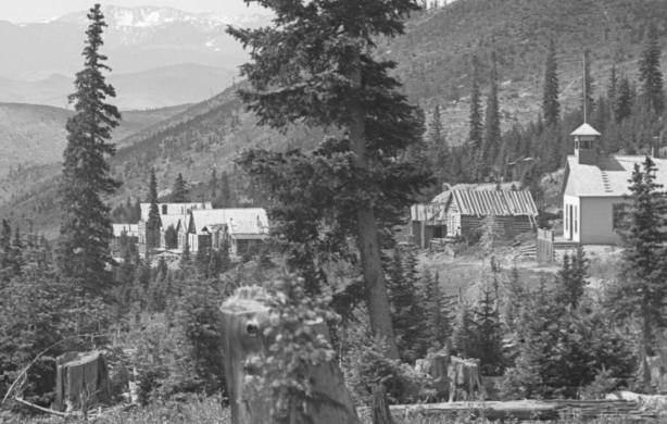
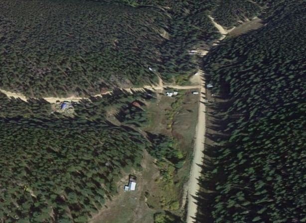
Baltimore still appears on maps and in many Colorado ghost town guide books. It sits just a quarter-mile or so off of Tolland Road, in a quaint meadow surrounded by dense pine and aspen trees, in between Rollinsville and East Portal. You can zoom in on Baltimore using satellite images, and you can see a cluster of newer buildings.

baltx3

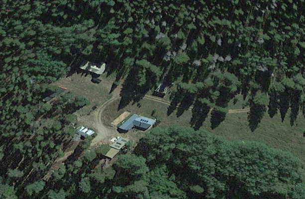
Satellite view of Baltimore today- Note only newer construction and one old relic survivor

That is as close as you will get though- The little road leading to Baltimore is chained off qnd posted “NO TRESPASSING”- Sometime, around 1990, maybe earlier, the town site was bought up by private interests, and public access to the spot ended. Today, all you will find is the chained off road, with Baltimore just out of eye’s reach.  I hopelessly drive by year after year, hoping to catch one of the property owners just so I can ask if I can take a quick peek, just to check Baltimore off my bucket list, but I have never been that lucky!

A few days ago, to my surprise, I received an e-mail from a follower of my Facebook page saying her family had a few photos taken in the 1950s during a visit to Baltimore, that they would like to share with me if I was interested. This offer brought a smile to my face, as very few images of Baltimore exist, and only a few written accounts can be found. Most of the photos accompanying this blog are thanks to that kind gesture from the Hawkins Family.

balt4

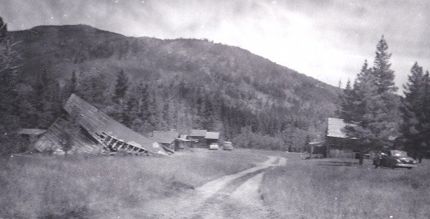
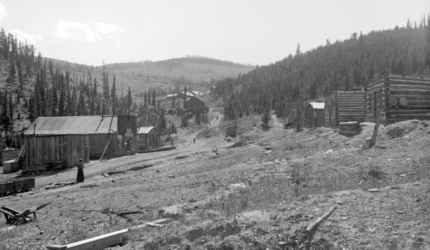
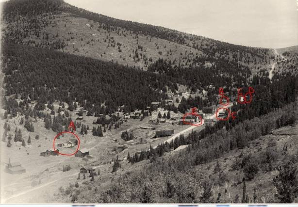
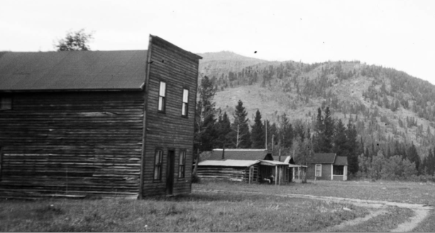
Baltimore in 1957, photo courtesy of the Hawkins Family

balt5

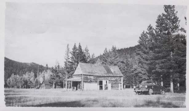
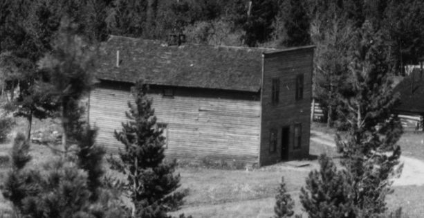
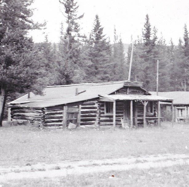
Baltimore Saloon and cabin 1957, photo courtesy of the Hawkins Family

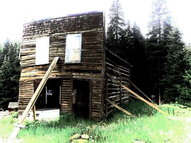
Baltimore was one of Gilpin County’s gold camps. Very little is known about the town, but from what little does exist, it sounds like it was fine place- Baltimore came to life around 1880, had a newspaper for a short time, a saloon, school, church, and surprisingly, an elabirately decorated opera house!

balt7

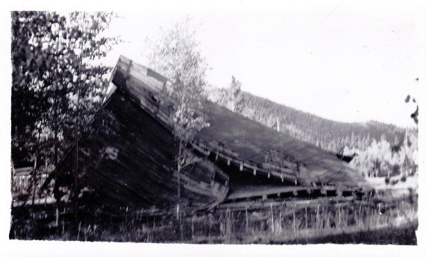
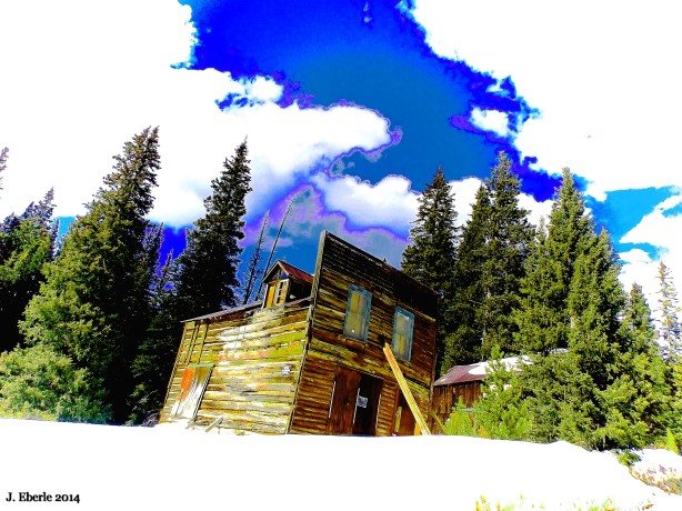
The collapsed Baltimore Opera House in 1957, photo courtesy of the Hawkins Family

Locals would pay opera singers from nearby Central City to come and perform in Baltimore. When famous artist and ghost town historian Muriel Sibell Wolle visited Baltimore in the 1930s, many decades after it had been largely abandoned, she noted the opera house still contained a piano and fine furnishings.

Balt

Baltimore Opera House in the 1930s prior to collapsing, photo found on the internet

baltx1

Another view Baltimore in the 1930s or 1940s, all is gone now. Photo found on the internet.

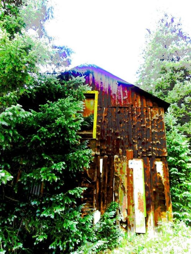
Baltimore faded around 1900, and most of the town was abandoned. It appears that a few of the residential cabins were used as summertime resort up until the 1930s, and some were possibly still in use into the 1950s.

balt2

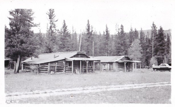
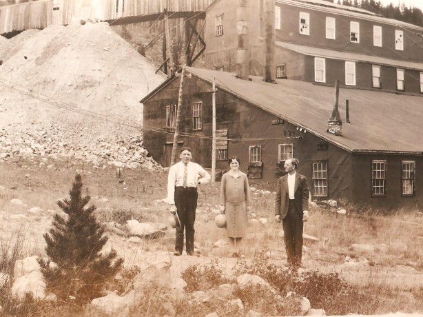
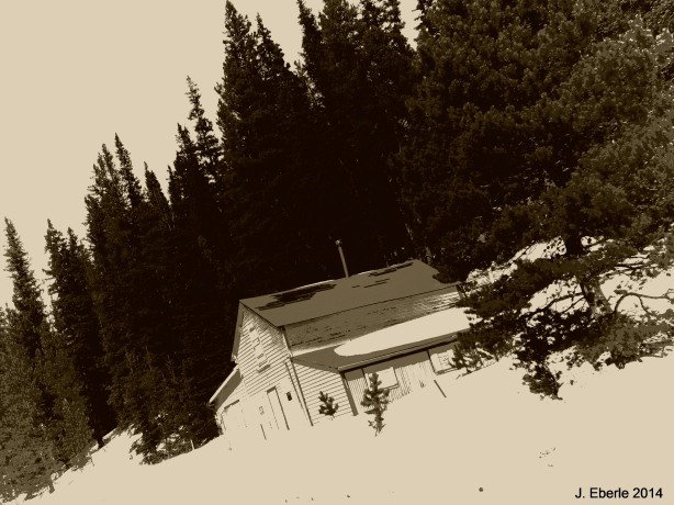
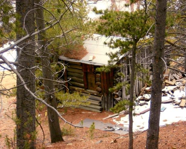
Baltimore cabins in 1957, photo courtesy of the Hawkins Family 

balt3

Detailed crop of the above photo, courtesy of the Hawkins Family

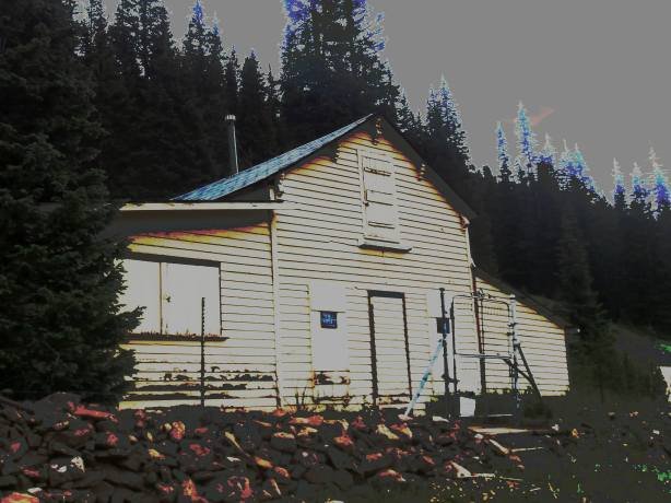
The once-fine opera house began to sag in the 1940s, and collapsed under its own weight in the 1950s. When developers bought the spot in later years, the tumbledown remnants of the residential cabins were demolished, or perhaps radically remodeled- Modern satellite images show what appears to be only newer construction homes at the site and only one remaining old structure- The remains of the saloon.  Some of the modern structures might hide remnants of old structures within their walls, but it is hard to say without having access to the site. In ghost town afficianado Kenneth Jessen’s books, he features an image of the sole survivor of Baltimore, taken in recent years,  before public access was blocked, but that is the only color photo I have ever found of the site.

balt6

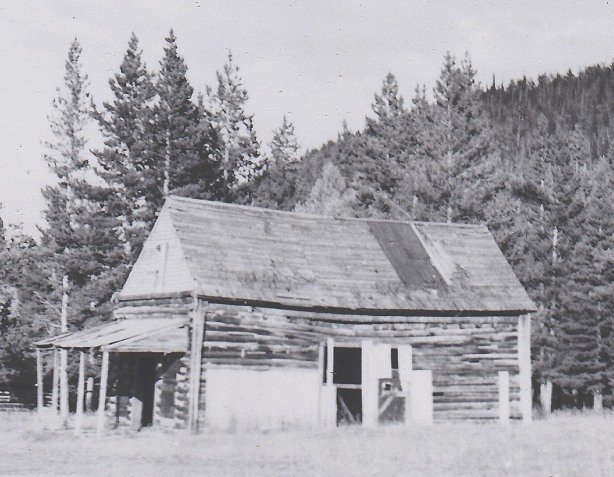
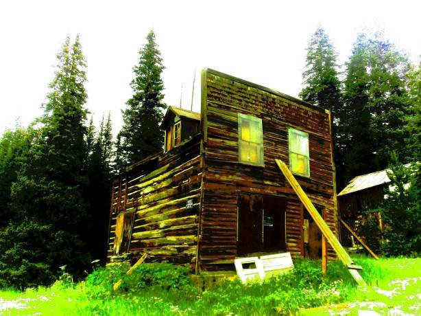
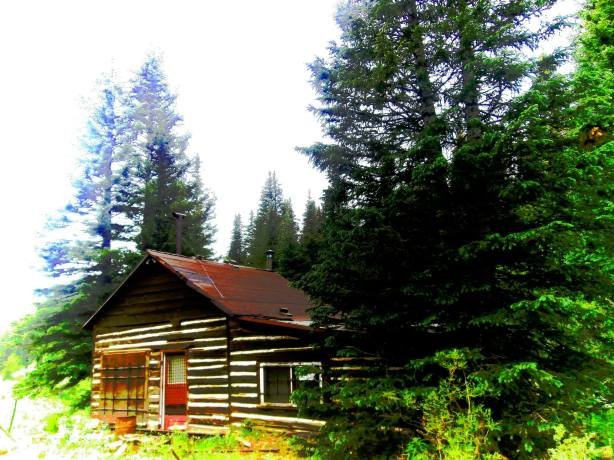
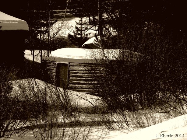
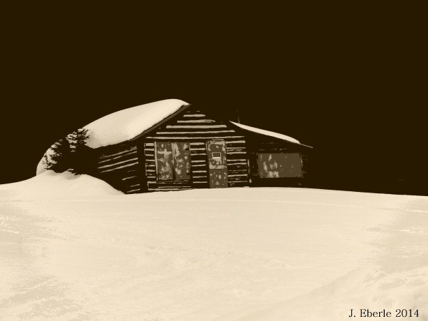
Baltimore Saloon 1957 (Hawkins Family photo)

baltx7

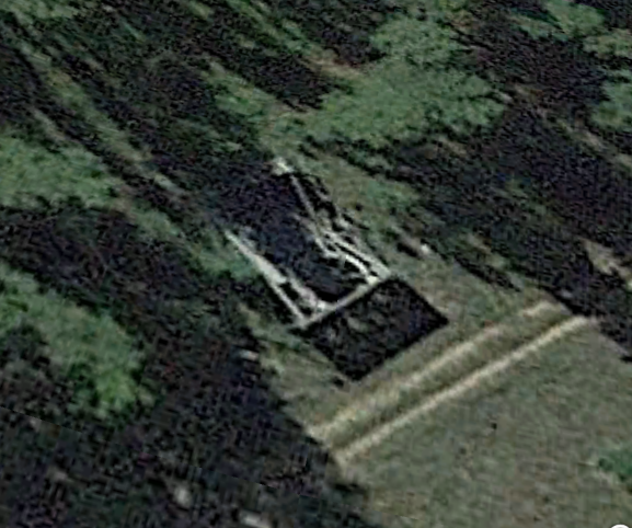
Baltimore Saloon today (Google Earth)

I would like to extend a huge THANK YOU to the Hawkins Family for sharing their photos of Baltimore, Colorado circa 1957!


Check Out My Book- Abandoned Western Colorado

MyBook

Coming August 24, 2020! Pre-Order Now! Abandoned Northern Colorado

NoColoGHPcover

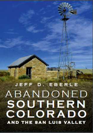
Coming September 28! Pre-Order! Abandoned Southern Colorado & San Luis Valley!

slvCOVER

Tucked away in Gamble Gulch about halfway between the towns of Black Hawk and Nederland, Colorado stand the sparse ruins of Perigo.  Perigo was a busy gold mining town in the latter years of the 19th Century and was home to several prosperous mines including the Golden Sun, Tip Top, Perigo and the Free Gold. A massive 60-stamp mill was erected at the town to crush the ores from the nearby mines.

Perigo had around three-hundred residents during it’s peak years. There was a general store, mine offices, the mill, several saloons, a social club and many private dwellings ranging from crude log cabins and tents to lavish two-story homes that would’ve been considered mansions in the day. Perigo’s social club put on plays and banquets, and tried on a number of occasions to entice the leading opera stars and actors from Central City and Denver to hold shows in the town- It is unknown, and doubtful that any ever accepted the offer.

perigoxx2

Perigo- A View Down Main Street Around 1890

When the mining industry collapsed in the 1890s Perigo began a steady decline into oblivion. The mines were all closed and the mill was shut down. Struggling on for a few more years was the general store that served the needs of those who still lived in Gamble Gulch, but soon, it too faded and was abandoned.

perigobook

Tourists visit the abandoned stamp mill around 1930

Sometime around the middle of the last Century a man purchased the entire town site, the mill, and all the remaining buildings and homes of Perigo.  The now ghost town of Perigo could still be visited and admired from the narrow and rocky road leading through Gamble Gulch.  Then one day the new owner was hit with a tax bill he could not pay. Gilpin County expected the man to pay property taxes on each of the structures on his property. He informed the county that all of the buildings were long abandoned and in various states of decay, but the tax man didn’t care, the law was the law and the taxes had to paid. Inviting the county tax assessor to Perigo, the owner showed him the rotten and collapsing buildings, but the county stood firm and demanded he pay up. A simple solution presented itself- If there were no standing structures on his property, the tax bill would vanish. So, unfortunately for old Perigo, the man filled the buildings at the town site with dynamite and blew Perigo off the map.


Today you’ll only find the twisted and shattered remains of the mill, some wood structures flat on the ground like a stack of popsicle sticks, a stone or concrete foundation tucked in the grass, and a couple of old tumbledown tin sided shacks being reclaimed by the earth.  One small Victorian era house still stands intact way back in the trees, and giant, still occupied, two-story Victorian style which may or may not be original to the site can be found near the mill wreckage.

Click Here for Colorado Ghost Town Guide Books by Jeff Eberle

I remember my first trip to Apex as a child very distinctly- We chugged down the bumpy dirt road in my dad’s old green Chevy pickup to a “neat place” he knew about just up the road. I was a little guy, probably 7 or 8 years old and my entire life at the time was fishing and baseball. Being in the mountains, I assumed Apex must be some place to fish, because, in my mind at the time, the only thing you did in the mountains was fish for trout. We finally reached a wide spot at the end of the road, and I was a little confused- there wasn’t anywhere to fish, just a cluster of falling down shacks and a few old buildings. I couldn’t understand why my dad had driven me up to this place where there were no fish??? I couldn’t understand why anyone would live in the mountains where there wasn’t a good trout stream or pond??? I was a little too young at the time to understand greed and “gold fever” and all those things that make men do strange things and travel to strange places. I wasn’t too upset though, because the tumbledown buildings were pretty interesting to a little kid.

That initial trip to Apex for me must have been sometime in the mid-1980’s. The memory always stuck in my mind for some odd reason, and the swaying, false-fronted building I first saw as a little kid at Apex is probably what got me hooked on the hobby of “ghost towning” today.

The old leaning false-fronted "hotel" in Apex. My first memory of the town.

The old leaning false-fronted “hotel” in Apex. My first memory of the town.

I ventured back up to Apex a couple of years ago to see what, if anything, remained of the strange place with nowhere to fish that I remembered as a kid. Although nearly 30 years had passed since that first glimpse of the town, I was happy to see Apex was still, relatively the same.

The first structures you'll encounter marking the Apex town site.

The first structures you’ll encounter marking the Apex town site.

apex4

Main Street Apex

Apex Hotel

Apex Hotel

The old swaying false-fronted building still stands proud, and is listed as “Site #001” in the Gilpin County Historical Society register. A small brass plaque is affixed the front of the precariously fragile old structure recognizing it’s historic significance. Apparently this was one of the Hotels in Apex during the boom years of the 1890’s, but I question that, the building seems a little to small to harbor more than one or two guests.

There is another tall, swayback, rickety building next door to the “hotel”. I can’t find any information on what this building was, but it was most likely a business of some sort. It is heavily overgrown and although a beautiful old building in many aspects, it just doesn’t photograph well. I’ve tried repeatedly to get a good angle on it, but the overgrowth around it, and the dark stained timbers that make up the building just make a good shot difficult…if I actually knew anything about photography I might get a decent image, but I’ve had no luck yet.

The great old building I can't get a good photo of.

The great old building I can’t get a good photo of.

It’s hard to imagine that this tiny cluster of cabins used to be a bustling city that served as the “capitol” of the Pine Creek Mining District in the 1890’s. An Idaho Springs newspaper wrote, during the boom years, that Apex boasted over 100 businesses on it’s Main Street and nearly 1,000 residents. Several stage lines ran through Apex daily, as well as daily mail service. The main gold mine in the area assayed at $1,800/ton by 1890’s numbers which today would equate to $110,500/ton! Vintage photographs show Apex had two, possibly three, north-south streets and one major east-west street (modern day Elk Park Road). Apex had several saloons and dance halls, a grocery store, hotels, mining company offices, a post office, a newspaper “The Apex Pine Cone”, and even a school house which still stands today just across the street from the leaning hotel. Apex fell victim to at least two forest fires which ravaged and destroyed much of the original business district, which is why so little of the town remains today when compared to old photographs. Oddly, for a large business center, I have found no record that Apex ever had it’s own cemetery. I assume residents were taken down the hill and buried in one of Central City’s cemeteries.

apex13

Main Street Apex in the 1890’s before the first forest fire.

apex12

The second street of Apex which still exists today, buried in the woods and marked “White Gulch Road”. One or two of these structures still stand, but I assume this road is on private property today.

apex11

Another shot of Main Street in Apex around 1900.

apex10

This is a view looking northeast at Apex. The highlighted buildings are the structures that remain to mark the site today. The false-fronted “hotel” can be seen at the upper left, highlighted, as the dirt road turns towards the right and heads up the hill out of town.

apex9

Another image showing remaining structures circled in red.

Apex is mostly abandoned, except for two or three people who have summer cabins in the area, and one extremely colorful year-round resident. If you are lucky (or unlucky) enough to meet the Mayor of Apex, be prepared to spend 15 or 20 minutes listening to all kinds of tall tales and fantastic stories of adventure, intrigue, espionage and the science of radio wave frequencies. I’ve met “The Mayor” twice, and he is a friendly and likable fellow…although I do suspect he may be a little on the insane side. He lives up Elk Park road in the cabin surrounded by snow mobiles in varying stages of decay. The Mayor will greet anyone with a smile and a handshake. He is unique though, and once he starts talking you won’t get a word in edgewise until he’s said his piece, so if you stop to shake hands, make sure you have some time to spare.

Heading up Apex Valley road off of Colorado 119 just past Black Hawk on the way to Nederland, a decent graded dirt road will take you to what’s left of Apex. At the town site the road branches- the left fork (Elk Park Road) will take past a few old cabins and up to “The Mayors” residence, after which the road gets rocky and steep and turns into a 4X4 trail that leads to the mining camps of Nugget, American City and Kingston up on Pile Hill, before dropping down into Mammoth Gulch. By going straight or taking the right fork of Apex Valley Road at the town site you will find the hotel, school house, and the other old structures marking what’s left of Main Street in Apex. The road continues north up Dakota Hill but there isn’t much to see.

Modern satellite view showing Apex Valley Road, the junction with Elk Park Road (left fork) and the road up Dakota Hill (straight, slight right)

Modern satellite view showing Apex Valley Road, the junction with Elk Park Road (left fork) and the road up Dakota Hill (straight, slight right)

My recent snooping around Apex also revealed a second north-south street buried in the trees. Just after you turn left on the Elk Park Road, a sign in the trees says “White Gulch Road” and you can see a couple of old cabins buried in the woods. I do not know if this road is public or private, so approach it with caution if you choose to investigate. I drove up the road once, and there are several foundations and an abandoned cabin or two along it. The road dead ends at gate marked “KEEP OUT” and what looks like a modern small-scale mining operation. My gut tells me it is probably a good idea to stay off this second road in Apex unless someone gives you permission.

a3 a4 a2

apex8

One of the “Fancy” houses in Apex

apex3

Main Street

apex2

A cabin buried in the woods at Apex

Apex March 2014, still hanging on!

Apex March 2014, still hanging on!

Apex has had a strange hold on me ever since my first visit. It’s not my favorite ghost town, and it’s certainly not the most interesting ghost town, but I always find myself in Apex when I’m in the area. When the winter snows begin to melt, Apex is one of the first high-country ghost towns you can access, and each thaw it amazes me that that old leaning false-fronted building has survived another winter without falling down.


MY GHOST TOWN PHOTOGRAPHY BOOKS ARE AVAILABLE AT:

http://www.blurb.com/user/store/Vicha603